Ex-Tropical Cyclone Ellie triggers record-breaking floods in Western Australia: December 2022
Ex-Tropical Cyclone Ellie caused havoc in Western Australia (WA) as it brought heavy rain and damaging wind to the region, cutting off towns, forcing road closures and transforming areas of the landscape into an inland sea (24). The cyclone saw homes and businesses being swamped, people evacuated and animals fleeing the affected areas (15). On 3 January 2023, Stephen Dawson, Emergency Services Minister, declared an emergency flood situation in Kimberley, WA (23). Over 200 people have been evacuated so far from the desert town of Fitzroy Crossing (18).
Event Timeline
Ellie first formed as a tropical disturbance on December 20 at 18:00 UTC over the Timor Sea. Over the course of the next two days Ellie intensified into a Category 1 Tropical Cyclone, finally making landfall at 11pm local time on December 22 close to the Daly River (southwest of Darwin), bringing strong winds and heavy rain across parts of WA and the Northern Territory (NT). A few hours later, Ellie began to weaken slightly and was downgraded to a Tropical Low (Depression). During the final days of 2022, the ex-tropical cyclone travelled west across the Kimberley coastline in WA and became mostly stationary throughout the first week of January, dumping continuous quantities of rain over the area. The weather system crossed east into the NT through 7-8 January 2023, before finally clearing south-east.

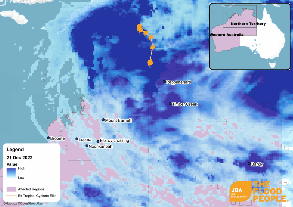
Figure 1: Satellite-observed rainfall animation showing rainfall evolution and path of Tropical Cyclone Ellie between 21 December 2022 and 4 January 2023. Green dashed line depicts approximate position of monsoon trough. Rainfall data source: NASA GPM (22). Tropical cyclone track data source: JWTC, 2022 via Storm Science Australia (27). Approximate location of monsoon trough: Bureau of Meteorology (BOM) (10). Video produced by JBA Risk Management, 2022.
Meteorological Overview
Heavy rainfall is not uncommon across northern parts of WA and NT at this time of year. The Australian monsoon, which occurs between the months of November to April, is characterised by seasonal changes in wind direction that are associated with greater-than-average rainfall in the north of the country.
The prevailing winds in this area usually originate from the east or south-east. During the summer months, the ground begins to heat up, producing an area of low pressure that causes the wind direction to switch to a northwesterly. These northwesterly winds pull in moisture-laden air from the Indian Ocean which acts as fuel for deep clouds and storms. Because the Australian monsoon is an annual occurrence, communities and ecosystems alike have adapted their lives according to it and are in fact dependent on the arrival of the rain (28).
What makes this event so unusual is the interaction between Ex-Tropical Cyclone Ellie and the monsoon. Usually once a cyclone makes landfall, the system rapidly weakens as its supply of moisture from below is removed. In this case however, Ellie’s storm system became embedded within the monsoon trough (an elongated region of low pressure), which acted to offset the weakening effects of the cyclone making landfall. The interaction between the two weather systems resulted in an unusually long period of unsettled weather, catching local residents off-guard.
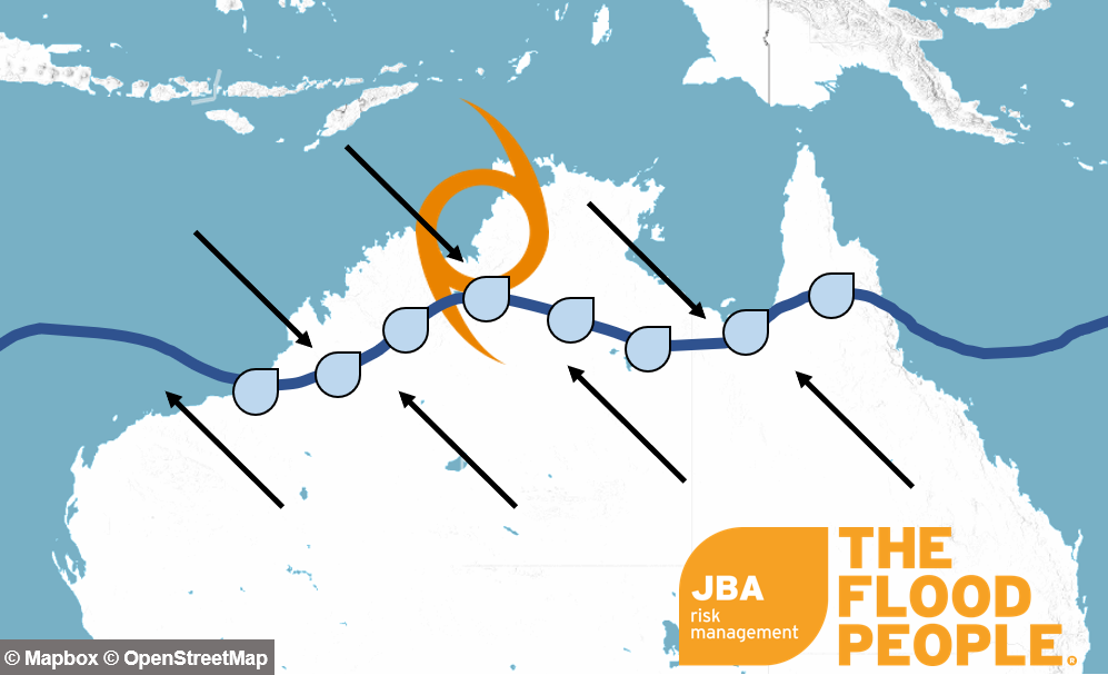
Figure 2: Simplified diagram showing the interaction between the Australian monsoon trough (dark blue line) and Ex-Tropical Cyclone Ellie (orange symbol). The black arrows depict the wind direction either side of the monsoon trough.
Impacts
The Kimberley region of WA experienced torrential rainfall, recording seven-day totals of 200-800mm. A 700km section of the Great Northern Highway - one of the major transport networks across the north of WA – was closed by authorities, isolating communities and prompting concerns over food and medical supplies. The Australian Government declared an emergency situation, resulting in evacuations across the region (16), (17), (21).
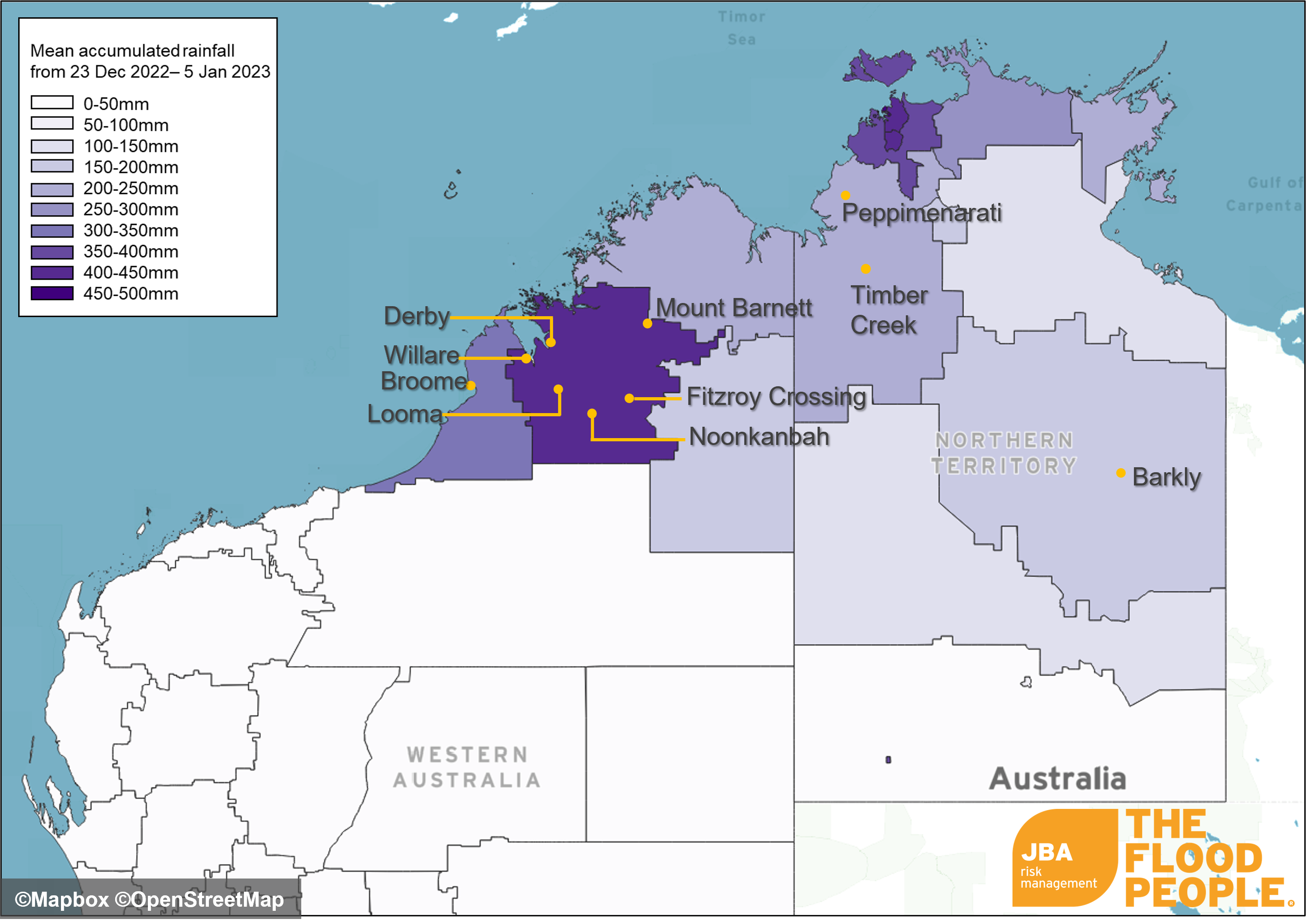
Figure 3: Average accumulated rainfall across parts of northern Australia between 23 December 2022 and 5 January 2023. Map uses publicly licensed rainfall data from the Bureau of Meteorology (9).
The town of Fitzroy Crossing was severely affected as the Fitzroy River reached its highest ever recorded levels. By 05 January, the Fitzroy Barrage station was recording a height of 17.2 metres, indicating major flooding. Over a thousand homes were inundated with floodwater, prompting evacuations to the town of Broome 400km west (8), (12).
Remote communities across NT were also affected, becoming isolated as transport networks were made impassable by floodwaters (1). Sections of the Victoria Highway near Timber Creek in NT were also made impassable by flood waters, and a woman had to be rescued after she was washed off the Bradshaw Bridge (13), built in 2008 with the aim of withstanding up to a 1-in-20-year flood (26). The Aboriginal community of Peppimenarti experienced severe wind speeds and heavy rain that destroyed the temporary housing of dozens of people displaced in 2020 due to ongoing civil unrest (2). However, despite some of the negative aspects of the flooding, for some cattle producers the rain was a welcome break after a long dry season (3).
Historical Context
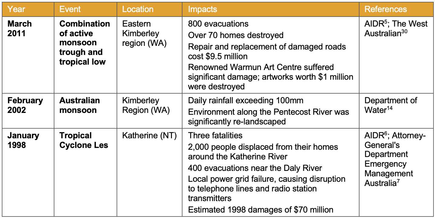
According to a report published by the Water and Rivers Commission in 2000 (31), the average annual flood damage cost for Australia is AUD $350 million, of which $17 million (5%) comes from WA. Insurance industry analysis by McBride (20) discovered that tropical cyclone activity (which includes both flood and wind perils) results in direct economic losses between AUD $40-100 million every year in WA. Table 1 lists the major impacts from three notable historical flood events across WA and NT caused by tropical cyclones and monsoonal rains.
Table 1: Historic flood events in WA and NT.
Back in April 2021, Tropical Cyclone Seroja made landfall across mid-western parts of Western Australia. The Category 3 storm affected Kalbarri and Northampton the most with about 70% of both towns’ structures damaged according to Insurance Council of Australia (ICA) (19). By August 2021, ICA had reported up to AUD $281 million worth of claims, 43% of which were personal while the remaining 57% were commercial. The recovery following the event was slow and difficult due to the prevalent COVID border restrictions. By November 2022, ICA concluded the event with a total of AUD $400 million of claims from Tropical Cyclone Seroja.
Extreme Value Analysis
JBA conducted Extreme Value Analysis on both rainfall and river streamflow data in order to estimate the return period of the event. We fitted a Generalised Pareto Distribution (GPD) curve to a 44-year daily rainfall climate data timeseries from NOAA (25) to produce a rainfall exceedance probability curve at Fitzroy Crossing. The curve is shown by the solid orange line in Figure 4, with the 70th percentiles given by the dashed lines. The observed daily rainfall at Fitzroy Crossing on 01 – 02 January (shown by the blue line) suggests a 1-in-250-year rainfall event.
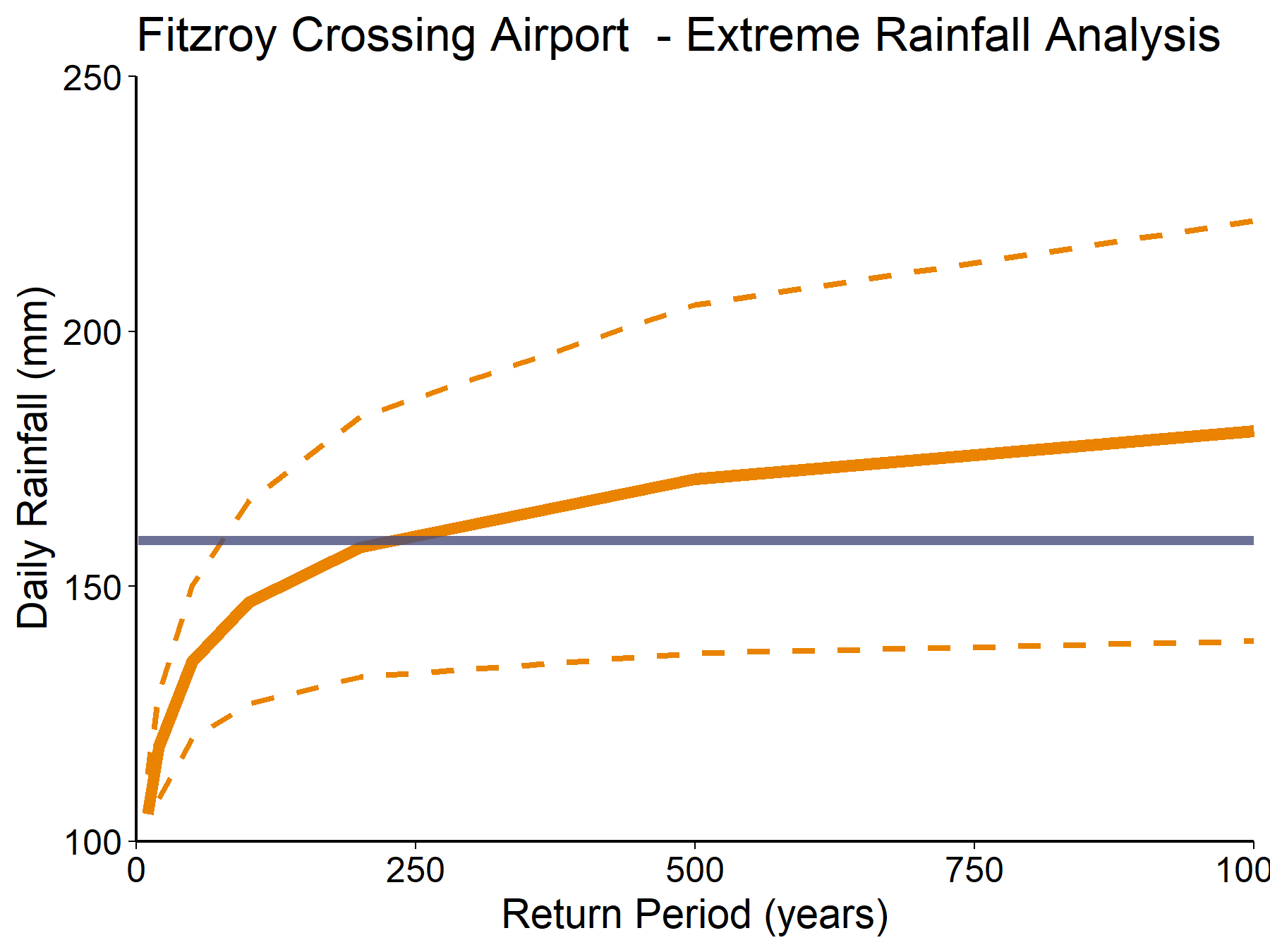
Figure 4: Estimated extreme rainfall return periods at Fitzroy Crossing based on daily rainfall totals from NOAA CPC gridded climate data. Observed 24-hour rainfall total (recorded between 02:00 to 02:00 AWST 01-02 January) is shown in context by the blue horizontal line (29)
The exceedance probability of streamflows along the Fitzroy River were calculated using daily maximum watercourse discharge data from the Department of Water and Environmental Regulation, accessed via BOM (11). The data were fitted with a GPD curve to produce exceedance probability curves at Fitzroy Crossing and Noonkanbah and are shown in Figures 5 and 6. The analysis suggests a streamflow return period of approximately 50 years.
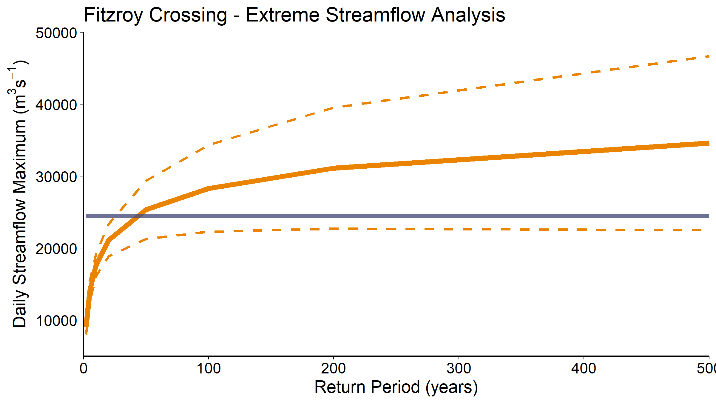
Figure 5: Estimated extreme streamflow return periods at Fitzroy Crossing (station 802055) based on daily maximum watercourse discharge data from 1957-2023. Observation (blue line) recorded on 02 January 2023.
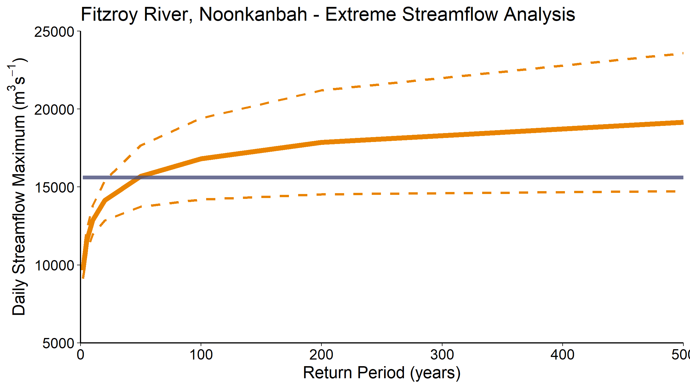
Figure 6: Estimated extreme streamflow return periods at Noonkanbah (station 802006) based on daily maximum watercourse discharge data from 1997-2023. Observation (blue line) recorded on 05 January 2023.
Fully comprehensive flood hazard maps
JBA have comprehensive river and surface water hazard maps covering all of Australia at 30m spatial resolution and six return periods: 20, 50, 100, 200, 500 and 1,500 years. Figure 7 shows a sample of our 1-in-50-year river flood map along the Fitzroy River, capturing the locations of Fitzroy Crossing and Noonkanbah. We additionally have high resolution (5m) maps covering major built-up areas including Adelaide, Brisbane, Melbourne, Perth and Sydney. If you are interested in licensing our hazard maps for Australia, please get in touch via the email below.
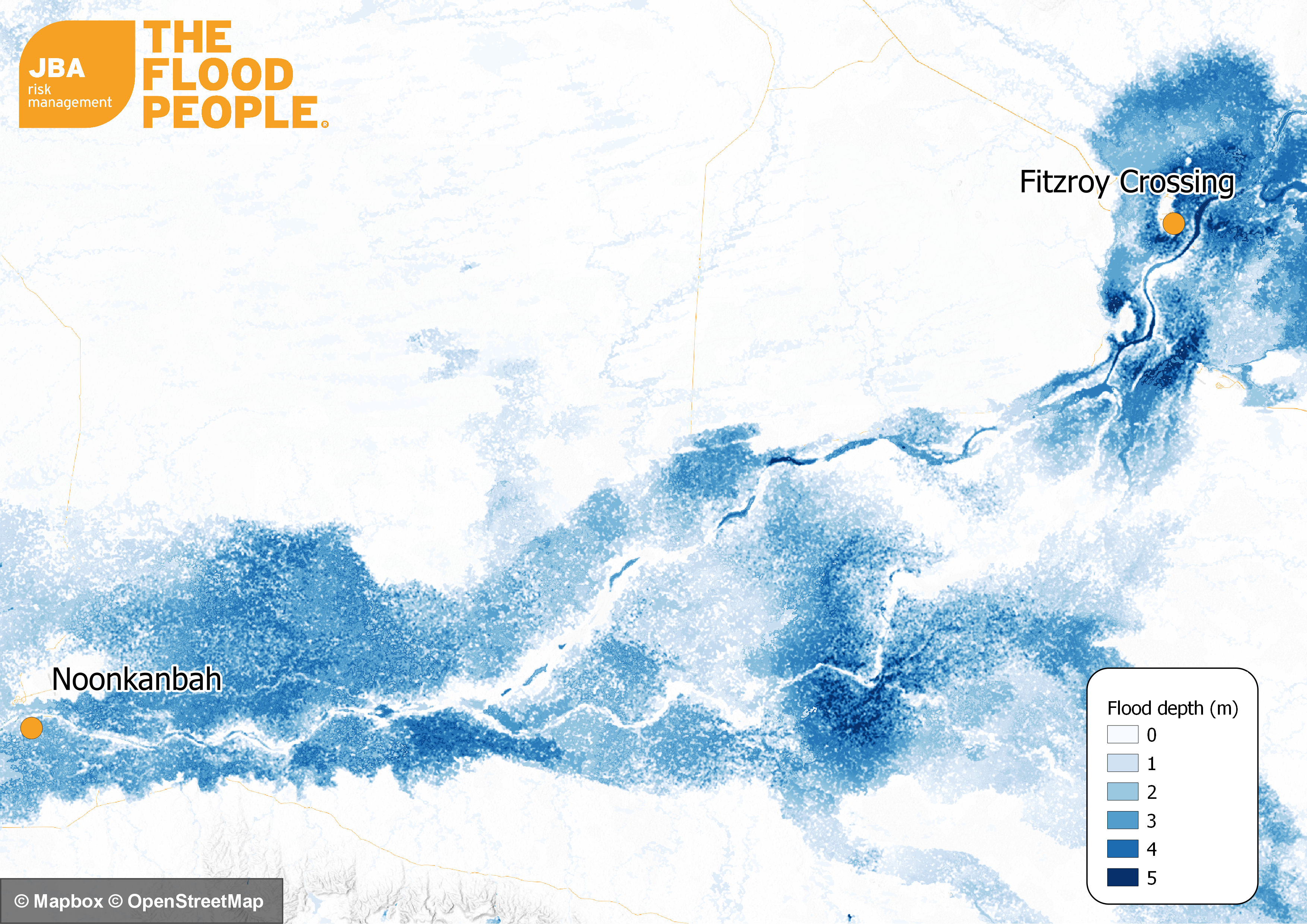
Figure 7: JBA’s 50-year return period river flood map showing depth and extent of flooding along a section of the Fitzroy River between Fitzroy Crossing and Noonkanbah.
If you're interested in finding our more about how our products or services can improve your management of flood risk, please get in touch for more information.
This report is covered by JBA’s website terms – please read them here.
References
(1) ABC News, 2022a. Major floods and wild weather isolate towns across northern Australia as ex-Tropical Cyclone Ellie maintains strength. [online] Available at: https://www.abc.net.au/news/2023-01-02/major-floods-wild-weather-for-northern-australia/101821962 [Accessed 05 January 2023]
(2) ABC News, 2022b. Family of man killed with crossbow in remote NT community preparing Human Rights Commission policing complaint. [online] Available at: https://www.abc.net.au/news/2022-12-24/peppimenarti-death-nt-police-human-rights-commission-complaint/101806812 [Accessed 6 January 2023]
(3) ABC News, 2022c. Ex-Tropical Cyclone Ellie gives Northern Territory stations much-needed drenching. [online] Available at: https://www.abc.net.au/news/rural/2022-12-31/barkly-cattle-stations-drenched-ex-tropical-cyclone-ellie/101817622 [Accessed 6 January 2023]
(4) ABC News, 2023. Australian Defence Force steps in as Kimberley's flood emergency intensifies. [online] Available at: https://www.abc.net.au/news/2023-01-04/defence-force-evacuate-stranded-wa-kimberley-residents-flooding/101826130 [Accessed 5 January 2023]
(5) AIDR, 2023a. Flood - Warum, Kimberly. [online] Available at: https://knowledge.aidr.org.au/resources/flood-warmun-kimberley-2011/ [Accessed 5 January 2023]
(6) AIDR, 2023b. Flood – Katherine. [online] Available at: https://knowledge.aidr.org.au/resources/flood-katherine-northern-territory/ [Accessed 6 January 2023]
(7) Attorney-General's Department Emergency Management Australia, 2006. Hazards, Disasters and Your Community (archived). [online] Available at: https://web.archive.org/web/20120813153201/http://www.em.gov.au/Documents/Hazards,%20Disasters%20and%20Your%20Community.pdf [Accessed 6 January 2023]
(8) Bureau of Meteorology (BOM), 2022a. [online] http://www.bom.gov.au/fwo/IDW62400/IDW62400.503017.tbl.shtml [Accessed 05 January 2023]
(9) Bureau of Meteorology (BOM), 2022b. Recent and historical rainfall maps. [online] Available at: http://www.bom.gov.au/climate/maps/rainfall/?variable=rainfall&map=totals&period=week®ion=nat&year=2023&month=01&day=05 [Accessed 6 January 2023]
(10) Bureau of Meteorology (BOM), 2023a. The Australian Monsoon. [online] Available at: http://www.bom.gov.au/climate/about/?bookmark=monsoon [Accessed 09 January 2023]
(11) Bureau of Meteorology (BOM), 2023b. Water Data Online. [online] Available at: http://www.bom.gov.au/waterdata/ [Accessed 09 January 2023]
(12) Daily Mail, 2022a. Isolated roads in the outback turns into an inland sea – with locals forced to use their boats to get around during the worst flooding in history. [online] Available at: https://www.dailymail.co.uk/news/article-11597167/Western-Australia-Kimberley-outback-towns-flooded-driven-cyclone-Ellie.html [Accessed 05 January 2023]
(13) Daily Mail, 2022b. Families cut off from their homes while Christmas shopping and woman almost drowns after being swept off a bridge as bone-dry town goes underwater in ‘once in 50 year’ flood. [online] https://www.dailymail.co.uk/news/article-11572483/Timber-Creek-cut-50-year-flood-Tropical-Cyclone-Ellie-hammers-northern-Territory.html [Accessed 6 January 2023]
(14) Department of Water, 2008. Water notes – The Kimberley river environment. [online] Available at: https://www.water.wa.gov.au/__data/assets/pdf_file/0017/3365/82109.pdf [Accessed 6 January 2023]
(15) Guardian, 2023. WA government declares emergency as record flood hits Kimberley. [online] Available at: https://www.theguardian.com/australia-news/2023/jan/03/wa-government-declares-emergency-as-record-flood-hits-kimberley [Accessed 5 January 2023]
(16) Guardian, 2022a. Fears for remote WA towns as Fitzroy River records one of the highest flow rates in Australia. [online] Available at: https://www.theguardian.com/australia-news/2023/jan/04/flood-hit-fitzroy-crossing-residents-worried-about-food-supplies-as-troops-deployed-to-kimberley [Accessed 6 January 2023]
(17) Guardian, 2022b. Authorities struggle to deliver food and essentials to towns stranded by WA’s ‘worst ever’ floods. [online] Available at: https://www.theguardian.com/australia-news/2023/jan/06/authorities-struggle-to-deliver-food-and-essentials-to-towns-stranded-by-was-worst-ever-floods [Acccessed 6 January 2023]
(18) Independent, 2023. Hundreds airlifted to safety by military helicopters as northwest Australia sees ‘once in a century’ floods [online]. Available at: https://www.independent.co.uk/climate-change/news/australia-floods-kimberley-ellie-cyclone-b2258115.html [Accessed 9 January 2023]
(19) Insurance Council of Australia (2021) Insurance Catastrophe Resilience Report: 2020-21. rep. Sydney, New South Wales: Insurance Council of Australia, pp. 1–24. Available at: https://insurancecouncil.com.au/wp-content/uploads/2021/09/ICA008_CatastropheReport_6.5_FA1_online.pdf [Accessed on 9 January 2023]
(20) McBride, John, 2012. The Estimated Cost of Tropical Cyclone Impacts in Western Australia. [online] Available at: https://www.researchgate.net/publication/272157780_The_Estimated_Cost_of_Tropical_Cyclone_Impacts_in_Western_Australia [accessed 09 January 2023]
(21) Metro, 2022. Kangaroos desperately huddle together on island to escape devastating floods. [online] Available at: https://metro.co.uk/2023/01/04/australia-kangaroos-huddle-together-to-escape-once-in-a-century-flood-18036807/ [Accessed 05 January 2023]
(22) NASA Global Precipitation Measurement (GPM), 2023. Precipitation Data Directory. [online] Available at: https://gpm.nasa.gov/data/directory [Accessed 06 January 2023]
(23) National Indigenous Times, 2023. Flood emergency declared as Fitzroy Valley hit by flooding. [online] Available at: https://nit.com.au/03-01-2023/4639/community-calls-for-help-as-fitzroy-valley-hit-by-flooding [Accessed 5 January 2023]
(24) Nine News, 2023. Emergency situation declared in Western Australia as outback transforms into inland sea. [online] Available at: https://www.9news.com.au/national/weather-update-kimberly-floods-emergency-situation-declared-in-wa-as-outback-transforms-into-inland-sea/8c1f348d-440d-4fef-abe4-86faac95228e [Accessed 5 January 2023]
(25) NOAA, 2023. CPC Global Unified Gauge-Based Analysis of Daily Precipitation. [online] Available at: https://psl.noaa.gov/data/gridded/data.cpc.globalprecip.html [Accessed 09 January 2023]
(26) Steel Con, 2023. Victoria Highway Upgrade (archived). [online] Available at: https://web.archive.org/web/20150311182554/http://www.steelcon.com.au/projects/bridges/victoriahighwayupgrade [Accessed 6 January 2023]
(27) Storm Science Australia, 2023. Tropical Cyclone Ellie. [online] Available at: https://www.ausstormscience.com/tropical-cyclones/tc-ellie/ [Accessed 09 January 2023]
(28) The Conversation, 2016. Explainer: what is the Australian monsoon? [online] Available at: https://theconversation.com/explainer-what-is-the-australian-monsoon-69411 [Accessed 05 January 2023]
(29) The Weather Chaser, 2023. Fitzroy Crossing Aero – Rainfall – Last 1 week Australia/Perth - Hourly data. [online] Available at: https://theweatherchaser.com/observations/rain-gauge/fitzroy-crossing-aero [Accessed 06 January 2023]
(30) The West Australian, 2011. After the flood – return to Warmun. [online] Available at: https://thewest.com.au/news/australia/after-the-flood---return-to-warmun-ng-ya-160757 [Accessed 09 January 2023]
(31) Water and Rivers Commission, 2000. Water facts - Flooding in Western Australia [online] Available at: https://www.water.wa.gov.au/__data/assets/pdf_file/0012/5313/11445.pdf [Accessed 09 January 2023]
Acknowledgment and Copyright
River streamflow data used in Figures 5 and 6 is provided by the Department of Water and Environmental Regulation, © Government of Western Australia:
- Water Information (WIN) database - discrete sample data. [09 January 2023]. Department of Water and Environmental Regulation, Water Information section, Perth Western Australia.