
Prolonged early‑monsoon rainfall triggers widespread flooding across southern and central China
In mid‑May 2026, exceptionally heavy rainfall triggered widespread flooding across southern and central China. The event caused multiple fatalities, displaced tens of thousands of people and led to significant disruption to infrastructure, agriculture and supply chains across several provinces.
The flooding developed rapidly as intense rain fell on already saturated ground, inundating towns and cities and overwhelming local flood defences. Occurring weeks before the peak of the East Asia monsoon season, the event highlights the growing challenge of increasingly intense and unpredictable rainfall in one of the world’s most economically and operationally critical regions.
Overview and timeline
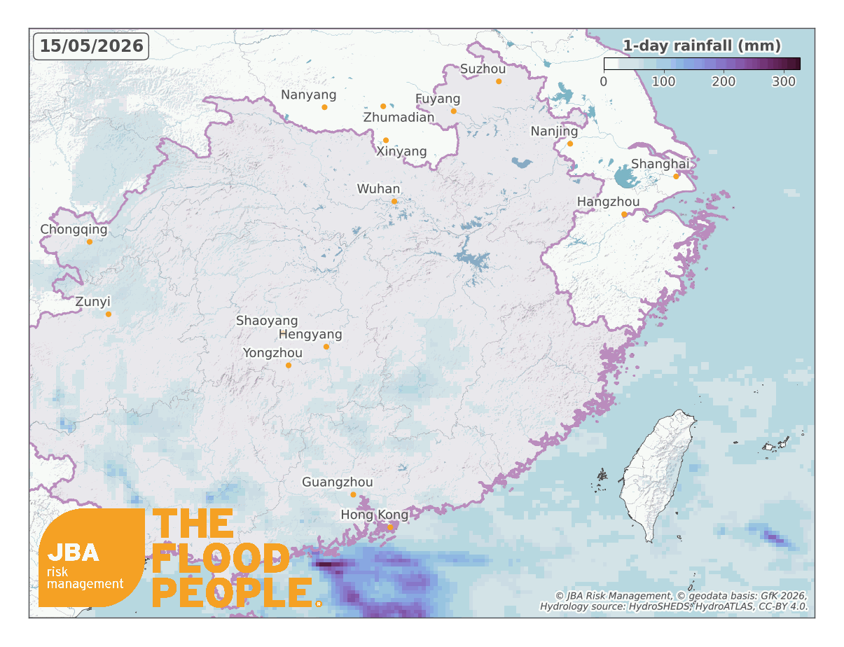
China experienced its first widespread and prolonged rainfall event of the year in mid-May 2026, driven by the convergence of warm, moist air sourced from the Bay of Bengal, South China Sea and Pacific Ocean. The result was a 1000 km-long band of slow-moving thunderstorms across southern and central China that brought record-breaking rainfall between 15 and 19 May (Figure 1; The Guardian, 2026a).
While this meteorological setup is not uncommon across southern China during the summer months, the early timing of the event is important. Driven by the East Asian summer monsoon, China’s flood season runs from June to August with rainfall peaking in July and accounting for 30 to 60% of the country’s annual precipitation (Ding and Wang, 2008). The May floods occurred several weeks before this peak bringing forward the start to the flood season and raising concerns that the region could face a longer period of elevated flood risk this year.
Impacts
Impacts intensified between 19 and 21 May as extreme rainfall fell across already saturated catchments. The rapid accumulation of rain resulted in flash floods, overflowing rivers, and landslides, prompting weather warnings, evacuations and the release of emergency response funds.
Flooding has mainly impacted communities around the Yangtze and Pearl river basins where some regions have received more than twice the typical rainfall for this time of the year (CGTN, 2026a). NASA Global Precipitation Measurement (GPM) satellite estimates indicate that more than 400 mm of rain fell across parts of Guangxi and Guangdong provinces over seven days (Figure 2), while Shimen county in Hunan province recorded 339.2 mm in 24-hours from 16 to 17 May (CGTN, 2026b).
Rivers responded rapidly, with parts of the Yu River rising by 5 m in two days, and five of its tributaries exceeding flood warning levels by up to 1.92 m (Xinhua, 2026a). Across China, 146 rivers in 18 provinces were under flood warnings (CGTN, 2026a), around 50% more than the average for the same period over the past five years (China Daily, 2026; CGTN, 2026c).

China’s emergency response framework is divided into four levels, of which Level I is the most severe (The State Council of the People’s Republic of China, 2026). The Ministry of Water Resources activated a Level-IV emergency flood response in seven provinces – Jiangxi, Hubei, Hunan, Guangdong, Guangxi, Guizhou and Hainan (Xinhua, 2026b).
Large parts of Duyun city were impacted when the Jianjiang River burst its banks in southwest Guizhou Province, triggering a Level III emergency flood response (Xinhua, 2026e). Properties along the river reported flood depths of up to 3 m and up to 2 m of mud after waters receded (New Tang Dynasty Television, 2026). Flood depths and extents in Duyun City closely matched JBA’s 50-year return period river flood map shown in Figure 3.
Official reports indicated at least 22 fatalities, with 24,000 people evacuated across Hunan, Guizhou and Hubei. The Chinese authorities have released 120 million yuan (USD $17.5 million) for disaster relief efforts for affected regions (Xinhua, 2026c), and an additional 110 million yuan to the Guizhou, Chongqing, Hunan and Anhui provinces (Xinhua, 2026d).

The flood also coincided with China’s planting and wheat harvesting season, disrupting agricultural operations in several areas. In Hubei and Henan, excessive rainfall caused premature sprouting in an estimated 4.8 to 10 million tons of wheat, making it unsuitable for food-grade flour (Reuters, 2026b). Further heavy rainfall was forecast for early June, further impacting grain harvests (CGTN, 2026c). The full impact on the 2026 wheat harvest remains uncertain, as 58% of the crop was still to be harvested later in the year.
Agricultural insurance in China is increasingly important in helping farmers cope with natural hazards such as floods. In early June, China Life Property & Casualty Insurance has received more than 360,000 agricultural insurance claims in 2026 covering around 263,300 hectares of farmland and major crops. The company has since paid out 2.9 billion yuan (~USD 430 million) in compensation (CGTN, 2026c).
Recent floods in China
China has experienced several major flood disasters in recent years, often linked to the summer monsoon and tropical cyclone season. In 2025, a particularly active monsoon and tropical cyclone season brought repeated flood events and some of the country’s highest recent losses.
According to China’s Ministry of Emergency Management (MEM, 2026), national average precipitation reached 668.0 mm in 2025, around 4.5% above the long-term average. The worst impacts were observed in southwest, south and north China, particularly in mountainous areas and densely populated river basins, where steep catchments channelled rainfall quickly into rivers, triggering river flooding, flash floods and landslides.
Tropical cyclone activity was above average in 2025, with 27 cyclones forming in the western North Pacific and South China Sea and 10 making landfall in China. Although the summer typhoons were relatively weak, more intense autumn typhoons caused widespread impacts across southern coastal regions, resulting in direct economic losses of 40.59 billion yuan (approximately USD 6 billion).
Overall, flood events between June and August accounted for 71% of total direct economic losses nationwide, equivalent to 166.58 billion yuan, or around USD 24 billion. Around 28,700 houses were destroyed, 362,600 were damaged, and more than 2.6 million hectares of cropland were affected. Table 1 provides a timeline of the main flood events and their impacts during the 2025 summer monsoon season.

China experienced an exceptionally wet year in 2024 with national average precipitation reaching 698 mm, around 9% above average. Rainfall during both the pre-flood and monsoon seasons was above average, contributing to widespread flooding across several provinces (MEM, 2025).
In April, heavy rainfall in Guangdong triggered major flooding and the evacuation of more than 110,000 people (Xinhua, 2024). Further flooding in Shaanxi and Hunan during July resulted in almost 200 fatalities (MEM, 2025). Nationwide, floods and landslides destroyed 58,000 homes, damaged a further 379,000 properties and caused direct economic losses of 263 billion yuan (approximately USD 36 billion) (MEM, 2025).
Tropical cyclone activity was also significant during 2024. Typhoon Yagi, the strongest typhoon to make landfall in China in a decade, caused direct economic losses of 72 billion yuan (approximately USD 9.9 billion) following landfall in Hainan in September (MEM, 2025).
The widespread flooding in 2024 and 2025 provides important context for the early-summer floods of May 2026. Significant flooding occurred before the peak of the monsoon season, a trend that has been observed again this year. Losses were concentrated in mountainous regions and densely populated river basins, highlighting the continued vulnerability of people, property and critical infrastructure to flood risk.
Climate drivers and changing flood patterns
Flood risk in China is influenced by large-scale climate patterns that affect rainfall across East Asia. Changes in ocean temperatures can alter atmospheric circulation, influencing the timing, intensity and duration of rainfall during the monsoon season.
Hou et al. (2025) found that unusually warm sea surface temperatures in the Indian Ocean can increase the frequency and intensity of pre-season rainfall across southern China. Their simulations showed that rapid ocean warming enhanced moisture availability and atmospheric convection, contributing to the extreme rainfall that led to major floods in 2024.
Two climate systems are particularly important in influencing the East Asian summer monsoon: the El Niño–Southern Oscillation (ENSO) in the Pacific Ocean and the Indian Ocean Dipole (IOD). El Niño, a warm ENSO phase, is often associated with enhanced rainfall across the Yangtze River basin and parts of northern China, while a positive IOD, warming in the western Indian Ocean, can increase rainfall across several major river catchments, including the Yangtze, Huaihe and Yellow rivers (Zhang et al., 2022).
El Niño conditions are forecast to develop during 2026, with NOAA estimating an 82% chance of El Niño by July (NOAA, 2026), and peak by autumn (Reuters, 2026a; WMO, 2026a; The Straits Times, 2026). The World Meteorological Organization also forecasts the potential development of a positive IOD later in the year (WMO, 2026b). Together, these climate patterns could influence rainfall across China during the second half of 2026 and into 2027.
While there remains uncertainty around the timing and strength of these large-scale climate phases, meteorological and government agencies are closely monitoring conditions. China’s National Climate Centre has forecast above-average rainfall for parts of the country, with communities being advised to stockpile emergency supplies at home to prepare for an extended period of elevated flood risk (The Guardian, 2026b).
JBA Flood Maps in China
As flood risk continues to evolve across China, high-resolution flood maps are increasingly important for public authorities, insurers, reinsurers, and businesses to understand exposure. JBA’s latest 30m China river and surface water flood maps combine high quality terrain, land-use and observational data to create granular flood extents and depths that allow users to assess how flood exposure varies across individual buildings.
JBA’s climate change maps at five different global warming levels help visualise the evolving flood risk as global temperatures rise under different climate scenarios. Figure 4 shows the riverine flood map in a scenario where global average temperatures rise by 2°C above pre-industrial levels in Hekou, a town located in Guangdong, which has also been impacted by the recent flood event.

Industry insight: (re)insurance market and protection gap
Despite the scale and recurrence of flood losses, insurance penetration for flood risk in China remains limited. During the July 2023 heavy rainfall event in the Haihe River basin, direct economic losses reached 166 billion yuan, yet only 7.6% of losses were insured, highlighting a substantial protection gap (Cui et al., 2025).
More broadly, China is estimated to face a catastrophe protection gap of around 90%, significantly exceeding the global average of approximately 50% (Insurance Asia, 2026). According to Ma et al. (2010), notes that 66% of China’s population and 80% of its GDP is threatened by floods. As exposure rises in major economic regions, the scale of this gap highlights the growing need for robust risk quantification and reinsurance support.
Although catastrophe insurance products have gradually emerged in the Chinese market, coverage remains constrained. In July 2024, insurers reportedly received at least 95,000 catastrophe-related claims, with total losses estimated at 3.2 billion yuan and insurance payouts of approximately 1.1 billion yuan, underscoring the continued mismatch between economic losses and insured recovery (UNDRR PreventionWeb, 2024).
This year, while China’s non‑life insurance sector is performing well financially, the reinsurance cession ratio for catastrophe risk remains low at around 10%, substantially below levels observed in more mature insurance markets (Insurance Asia, 2026). This limits the sector’s ability to efficiently transfer peak flood risk and scale affordable coverage.
Research by Watanabe et al. (2025) indicates that China has reduced flood damage over time through sustained investment in flood protection, with major disaster events, fiscal capacity, and policy shifts playing a key role in shaping long‑term resilience spending.
However, despite these structural improvements, “public's willingness to purchase flood insurance and the insurance companies' willingness to offer flood insurance are relatively low” (Cui et al., 2025), contributing to a persistently wide protection gap in a country that continues to face evolving flood and cyclone risk.
How JBA can help
Understanding how flood risk varies from building to building is essential for managing exposure. For insurers and reinsurers seeking to reduce the flood protection gap, and for financial institutions stress testing their portfolios, access to high-resolution flood hazard data is increasingly important. Such data helps identify where risk is concentrated and how it may change over time.
JBA's flood hazard data and catastrophe models help insurers, reinsurers and financial institutions better understand flood exposure, quantify risk and make more informed underwriting, lending and investment decisions. By providing detailed insights into flood hazard at the asset level, JBA supports risk selection, portfolio management and the development of more resilient risk transfer and risk management solutions.


