
Storm Babet unleashes chaos across the UK
Strong winds and torrential rain caused by Storm Babet brought unprecedented flooding to various parts of the UK and Ireland. Seven people are known to have died in weather-related incidents since the storm made landfall (Independent, 2023a). A rare red warning of a “danger to life from floodwater” was issued by the Met Office in eastern Scotland, where flood defences were breached (Sky News, 2023). After meeting the affected residents in Brechin, one of the worst flood-hit areas, Scottish First Minister Humza Yousaf pledged government support. “It's clear that the devastation of the storm is unlike anything that they've seen,” he said (BBC, 2023a).
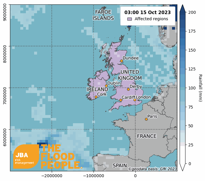
Event Overview
Storm Babet made landfall on 18 October 2023 as heavy rain sparked flooding, disconnecting towns and villages. The red warning issued for rain was the first since the warning raised during Storm Dennis in February 2020 (Guardian, 2023a). The Met Office still had more than 140 red and amber warnings for flooding on 25 October (Gov.uk, 2023). Affected areas in the UK include east Scotland, Derbyshire and surrounding counties, north Wales and County Cork in Ireland. Hundreds of people were evacuated across Great Britain whilst 1,250 properties in England alone were flooded in areas including the East Midlands and Yorkshire and Humber (BBC, 2023b).
Around 100,000 Energy Networks Association customers were affected by power outages in the UK, (ENA, 2023), whilst travel was also severely disrupted as chaos hit trains, ferries and airports, with Leeds Bradford Airport forced to close after a plane skidded off the runway whilst landing (BBC, 2023c). London’s King’s Cross train station was forced to close because of overcrowding (Independent, 2023b). Agriculture also took a hit, with farmers in the north and east of Scotland left facing huge losses. Farmlands were submerged under water, as floods washed away crops and livestock (Press and Journal, 2023), with winter and spring cereal and potato crops likely to be left to rot in the ground following the prolonged waterlogging of fields (Guardian, 2023b).
Some weather stations in County Cork recorded over 100 mm of rainfall in a 36-hour period. In Midleton, one of the worst-hit communities, 250 homes were flooded (Irish Times, 2023). In Scotland, Waterside Perth, a station north-west of Brechin, recorded almost half of the station’s total recorded rainfall since the start of 2023 (Courier, 2023), with 200 mm rain recorded between 9am on 18 October and 9am on 20 October (SEPA, 2023a).
Meteorological Overview
The extraordinary intensity of Storm Babet was a result of teleconnections between weather events across the globe. In the week before Storm Babet’s formation, a category 5 Typhoon called Bolaven hit Japan and moved northwards into the north Pacific, injecting warm, moist tropical air into the jet stream in the upper troposphere. The advection of such air caused the jet stream to “wobble” from its previous trajectory, generating larger peaks and troughs downstream over North America and Europe, influencing surface weather conditions (Washington Post, 2023). In the days leading up to Storm Babet’s arrival over the UK and ROI, a surface low pressure system in the Bay of Biscay began to form. The jet stream, affected by the advection of lower tropospheric moisture, moved into an unusual position that allowed for the rapid intensification and northward movement of Storm Babet from the Bay of Biscay (Independent, 2023c). The storm began to slow and stall over the UK and Ireland on Thursday into Friday, resulting in strong winds and very high rainfall accumulations. By Saturday, a second area of low pressure moved northwards causing further heavy rain in the south and south-east of England (Met Office, 2023).
Return Period Estimation
JBA conducted Extreme Value Analysis on historic rainfall and streamflow data in order to estimate the return period of the event. We fit a generalised Pareto distribution to a 44-year daily rainfall climate data timeseries from NOAA (2023) to produce a rainfall exceedance probability curve for Derby in the north Midlands and Mold in North Wales. The curves are shown by the solid orange lines in Figure 2, with the 95th percentiles given by the dashed lines. The observed 24-hour rainfall total of 41.4 mm in Derby (shown by the blue lines) suggests around a 1-in-40 year rainfall event and the 39.6 mm of rainfall received in Mold suggests around a 1-in-30 year rainfall event.

The exceedance probability of streamflow on the River Rother at Woodhouse Mill near Sheffield was calculated using daily mean watercourse discharge data from the National River Flow Archive (NRFA, 2023). The 62-year time series data were fit with a generalised Pareto distribution to produce the exceedance probability curve in Figure 3. The streamflow of 118 cubic meters per second on 21 October 2023 equates to a return period of 200 years during Storm Babet. River Owennacurra, which flows through Midleton in Co Cork, Ireland, recorded a streamflow of 25.9 cubic meters per second on 18 October 2023, equating to a 1-in-135-year event for this location (Figure 3).

The river level for the South Esk that flows through Brechin, Scotland, rose rapidly from the afternoon of 19 October 2023 to the early hours of 20 October 2023 when the river gauge became inoperative. It was reported by Angus Council (2023a) that the river level in Brechin reached 4.4 m which would equate to a 1-in-145-year river flood event during Storm Babet (Figure 4). The defences at Brechin are designed to protect against river levels of 3.8 m which would be a 1-in-60-year event (Angus Council, 2023b).

Historical Events
The UK and Ireland have a long history of extreme weather events and named storms resulting in severe weather warnings. Significant historic events which each resulted in disastrous flooding across the countries are listed below.

JBA Flood Hazard Maps
JBA have national 5m resolution river, surface water and coastal storm surge flood hazard maps for the UK and Republic of Ireland.
JBA’s flood footprint for the event details extents and depths of the flooding in areas affected. Download it via our Client Portal or request a copy by emailing eventresponse@jbarisk.com.


