
Torrential rainfall overwhelms Mediterranean countries
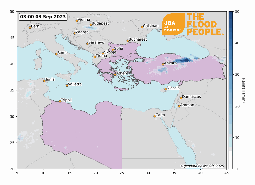
In early September 2023, three days of extreme rainfall triggered by Storm Daniel submerged central Greece, washing away roads, isolating towns, cutting off power, and trapping people. Flooding also affected Turkey and Bulgaria with at least 22 people losing their lives across the three countries (ABC News, 2023). Central Greece received more than a year’s worth of rain in just a day, with the country’s agricultural hub severely affected (Guardian, 2023a). The Greek Prime Minister said that the country is dealing with an unprecedented natural phenomenon which they have never witnessed before (BBC, 2023a).
The floods in Europe were followed on 11 September by a devastating national disaster in Libya, as Storm Daniel’s extreme rainfall caused two dams to burst in the city of Derna, leading to at least 5,000 deaths and likely many thousands more (BBC, 2023b).
Event Overview
Beginning on 5 September, the storm brought 754mm of rain to Zagora in Magnesia, Thessaly – the highest-ever daily rainfall total recorded in the country. The heavy rains fell on Greece after a devastating two weeks of the largest wildfires Europe has ever seen (Guardian, 2023b), which causes increased flood risk from burn scars and soil developing water repellant layers (NWS, 2023). Places including Sporades and Evia were hit by severe flooding. In Turkey, floods damaged several buildings and roads as they affected the northern districts of Istanbul and Kirklareli Province. In Bulgaria, Tsarevo, a resort town on the Black Sea suffered the brunt of the damage. Multiple rivers overflowed, destroying a number of bridges which disrupted the lives of thousands of people (FloodList, 2023a).
As of 10 September, according to Greek Civil Protection, authorities had evacuated 5,620 people overall, including more than 3,500 in Thessaly, central Greece, which is one of the worst-hit areas (ReliefWeb, 2023). Over 70,000 hectares of farmland in the Thessaly region were flooded, affecting summer fruit and vegetable crops (Kathimerini, 2023). The Greek Prime Minister Kyriakos Mitsotakis has requested aid from the EU as initial estimates show that the damages could cost around €2.5 billion (USD $2.67 bn) (Euractive, 2023).
On 11 September the storm moved over the Mediterranean to bring devastating flooding to Libya. Cities near the eastern coast were most affected, with authorities in the East Libya region (a semi-autonomous region not recognised internationally) saying that the death toll in the cities of Benghazi, Sousse, Derna and Al-Marj was already above 2,000 and may be many more by the time the flood waters recede (BBC, 2023c). On 12 September two dams in the port city of Derna burst, with 10,000 people listed as missing (Irish Times, 2023). Egyptian migrants have also been killed by the floods with 145 bodies being sent home to Egypt from Libya (Ahram Online, 2023). This disaster has come after an academic report published last year warned of the Derna dams being vulnerable to bursting if an event similar to the 1959 Libya floods were to hit the country (Guardian, 2023c). The UN’s World Meteorological Organisation (WMO) have spoken out on the disaster in Libya, saying that thousands of lives could have been saved if warnings were issued (BBC, 2023d). The political situation in the country makes responding to disasters difficult and the WMO has attempted to improve Libya’s meteorological systems in the past, but it says security threats hampered the efforts.

Meteorological Overview
Storm Daniel developed from a well-known meteorological phenomenon called an omega block (Guardian, 2023d). An omega block is characterised by its upper and lower tropospheric features. In the upper troposphere, the jet stream forms a pattern that resembles the uppercase Greek letter omega, and closer to the surface, two low pressure systems form to the east and west of a high-pressure system. The low-pressure system on the eastern side of this omega block partly explains Storm Daniel’s intensification.
Exceedingly warm sea surface temperatures across the Ionian and Mediterranean Seas allowed Storm Daniel to strengthen further. Sea surface temperatures across the Mediterranean were reported to be above average during July and August (Copernicus, 2023a), providing additional heat and moisture that fueled the storm. A week after being named, Daniel developed into a “medicane” (Mediterranean hurricane), forming the classic “eye” characteristic of hurricanes and cyclones that normally form in larger oceanic basins (Copernicus, 2023b). Although medicanes are typically weaker than hurricanes, Daniel still produced high precipitation rates and destructive flash floods as it made landfall in Libya.
Recent historical events
On 3 June 2019, heavy rains caused flash flooding in the Ghat District of south-west of Libya, resulting in four deaths and over 4,000 people displaced (ReliefWeb, 2019). Parts of the city were left without drinking water and electricity for two days (FloodList, 2019).
On 18 September 2020, Greece was hit by Medicane Ianos which caused flash flooding and landslides. Record-breaking daily accumulated rains fell, with 644mm recorded in Kefalonia (K. Lagouvardos, et al., 2022). Four people died and around 5,000 homes were affected by the flooding (BBC, 2020). One village alone was estimated to have suffered over 50,000 Euros in damages (Greek City Times, 2020), but the overall estimate cost of the storm was over $100 million USD (AON, 2020).
Turkey was hit by flash floods in early July 2023, with more than 250mm of rain falling in 24 hours and hundreds being evacuated (FloodList, 2023b). One person died and more than 500 people were rescued and evacuated from flooded villages in Düzce Province.
Storm rainfall intensity is expected to increase with climate change and direct flood damages are projected to increase by 1.4 to 2 times with a 2-degree Celsius warming scenario (IPCC, 2023). All things being equal, 7% more moisture is held in the air with each degree of atmospheric warming, causing a general expectation of increased precipitation. In addition, storms may begin to move more slowly in the future, causing them to last longer over single areas, thus resulting in increased rainfall intensity. One study projected slow moving storms across land to become 14 times more likely by 2100 in a high emissions scenario, attributed to a weakening of the jet stream due to arctic amplification (Kahraman et al., 2021). These slow-moving extreme precipitation events are also projected to become more frequent in the Mediterranean Sea later in the calendar year, extending the storm season.
It’s vital that organisations act now in response to flood risk. We offer flood mapping and probabilistic flood modelling worldwide, including for Greece, Turkey, Bulgaria and Libya, which provides flood risk insights at any location globally. This can help re/insurers, financial organisations, and the International Development sector to better understand and manage flood risk.
To find out more about our flood data and how it can help you, get in touch with the team.
This report is covered by JBA’s website terms – please read them here.


