
Australian Outback faces worst flooding in decades
Monsoon-like weather where tropical moisture surges, coupled with ex-Tropical Cyclone Diane, has caused flooding in central and southwestern parts of Queensland, Australia. From mid-March 2025, the inland regions of Queensland started seeing high rainfall, leading to the swelling of rivers and creeks like Bulloo. This prompted evacuations in the Outback towns such as Thargomindah and Eulo. By 24 March 2025, there was major flooding, and flood levels peaked between 27 March and 2 April. This rare event has resulted in floods of about 700,000 km², inundating homes in small towns, destroying crops and causing the loss of over 150,000 livestock.
Meteorological overview
According to the Australian Broadcasting Corporation (ABC, 2025a), the flood event was driven by an inland low-pressure region that drew moist air from the tropical north to the arid south. This influx of moist air resembled monsoonal winds commonly seen within the tropics, prompting this event to be dubbed a “pseudo-monsoon”. While surges of humid air to inland Australia are common during the wet season, this event saw an exceptional southward spread of moist air into northern New South Wales (ABC, 2025a).
Two large-scale ocean-atmospheric interactions were pivotal in facilitating the flow of warm, moist air. First, the Arafura and Timor Seas were unusually warm in 2024, which resulted in high evaporation rates that fed the inland low-pressure system with moisture from the north (The Conversation, 2025a; The Conversation, 2025b). Additionally, a positive Southern Annular Mode allowed westerly winds across the Southern Ocean to shift further south, facilitating the unimpeded flow of easterly winds extending from Fiji that brought even more moisture to southeastern Australia (The Conversation, 2025b).
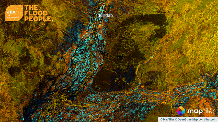
As these two streams of moist air converged at the low-pressure troughs inland, the air was lifted to higher and colder parts of the atmosphere, triggering the formation of rainbands that stretched over 2,000 km (ABC, 2025a). Within the week of the event, parts of Queensland received more than 400 millimeters of rain — bringing the total monthly rainfall to five times the average rainfall in March (BoM, 2025c; BoM, 2025d). The floods that followed in Stonehenge, Windorah and Jundah exceeded the levels of the 1974 event, which was a significant year for outback flooding and the wettest year in Australian records (NASA, 2025; BoM, n.d.).

Due to the high volumes of rainfall over the prior weeks, rivers in the Outback rose to levels above the major threshold; as seen in Figure 1 and Table 1, the most impacted areas saw water levels rise above 8m.
Table 1: Three river stations within the affected area and corresponding peak water levels and major threshold levels (Source: BoM, 2025b).

The flood extent is estimated to be 700,000 km², which is about four times the size of Victoria and almost the size of Egypt (The Guardian, 2025a).
Impacts
Entire towns were evacuated as floodwaters crept into their streets. Smaller rural communities were rescued by helicopters and brought to nearby towns. Residents of Adavale were evacuated to Quilpie, and those from Jundah were brought to Longreach (The Guardian, 2025a). With roads flooded, communities like Yowah and Barcoo Shire turned into inland seas, trapping residents without access to healthcare, food and fodder (The Guardian, 2025b; The Guardian, 2025c).
Farmers in the region suffered devastating losses to their properties and livelihoods. Initial damage assessments estimate a staggering death toll of 150,000 livestock, which includes 70,000 cattle, 70,000 sheep and 10,000 goats and horses (The Guardian, 2025c). Those animals that survive will have to overcome thick mud and sticky clay and are susceptible to illnesses (The Conversation, 2025b). The recovery process will involve the repair of 4,700 km of damaged private roads and 3,500 km of fencing that is crucial for protection from canine predation (The Guardian, 2025c). Graziers anticipate that it will take at least six months of intensive recovery effort to get their farms back up and running (ABC, 2025b).
Less than a year ago, the Minister for Agricultural Industry Development and Fisheries and the Minister for Rural Communities released a statement noting that the agricultural sector would flourish with an expected value of AUD $23.56 billion in 2024-25 (Queensland Government, 2024a). As seen in Table 2, the rough estimate of ten local government areas within the affected area contributes about 5% of Queensland’s agricultural economy, valued at AUD $881.5 million as of 2024, which includes livestock and livestock production. With the current floods in the Outback, which came shortly after the flooding caused by ex-TC Alfred and the north Queensland floods in February, the agricultural sector in Queensland would face a setback.
Table 2: Extracted 10 local government areas which are impacted by the floods and the corresponding 2024 gross value agricultural production from the Department of Primary Industries (Source: Queensland Government, 2024b).

Notable historical events
Unlike Queensland's eastern coastal regions, the Outback typically experiences less frequent flooding due to its arid and semi-arid climate. However, flood events have still occurred periodically, although the extent of impact was not as severe as in the current floods.

JBA products and services
JBA provides both flood maps and an inland flood model for Australia. Our flood maps include:
- Fluvial and pluvial maps at 5m resolution in main cities like Brisbane and 30m resolution everywhere else
- Coastal maps at 30m resolution
For more information on our newly released flood model, please refer to our press release.


