
Understanding the likelihood that future floods surpass our historic experience and how severe those events might be, is a requirement of the insurance industry if it is to be confident that it can help support communities and businesses after an event has occurred. The modelling approaches required to do this are scientifically complex, and a topic of continuous development and improvement. In this blog, John Ashcroft and Alison Poulston introduce JBA Risk Management’s recent collaboration with NVIDIA where we have trialled AI-powered weather prediction models through NVIDIA’s Earth-2 platform to more robustly sample low-frequency, high-severity events. Using the example of the Elbe catchment in Germany, a river basin supporting around 25 million people (ICPER Secretariat) and encompassing major cities such as Prague, Berlin and Hamburg, they show how this AI-driven approach can be applied to assess flood risk over the winter period in the context of a recent impactful season.
A European winter primed for widespread flooding
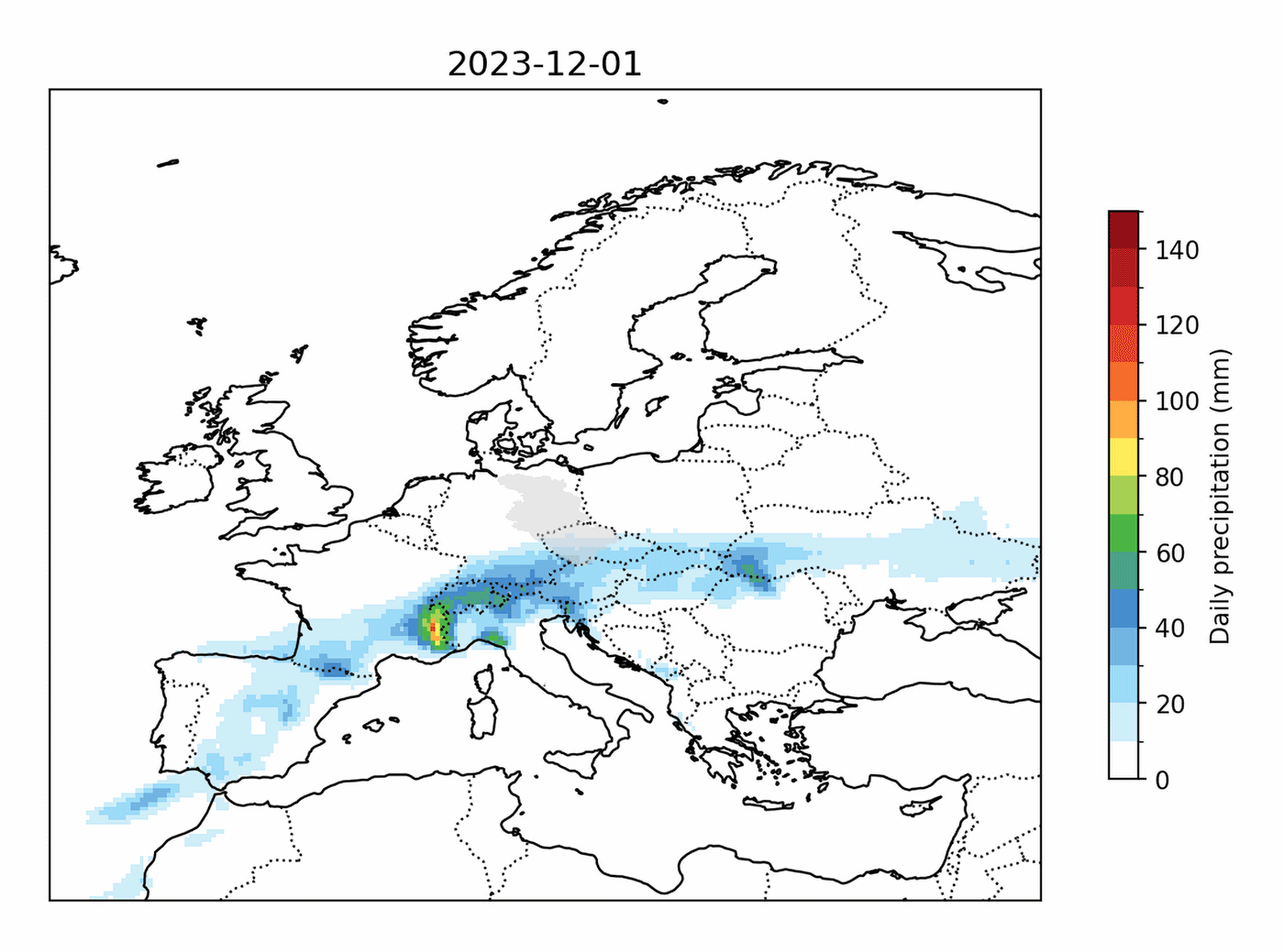
In the 2023/4 winter season (i.e., December 2023 to February 2024; Figure 1) over 220,000 people were affected by flooding on the Elbe (estimated with JBA’s catastrophe model with WoldPop population data and a flood depth threshold of 20cm; Figure 2). This made it the second most impactful winter of flooding for the region since 1981. However, this flooding was not caused by a single extreme storm – the maximum 1-day precipitation across the season for Berlin was not in the top five historic years. Rather, saturated ground caused by a persistently wet 2023 (approximately 7% wetter than average over Europe; EFAS) made the catchment more susceptible to rain storms causing river floods. Coupled with consistent moderate rain (Berlin did receive the highest total winter precipitation on record), the region experienced numerous flood events.
This raises important questions. Under slightly different conditions, how much worse could the flooding of winter 2023/4 have been? Did Germany get ‘lucky’ in winter 2023/4, narrowly avoiding a devastating winter of flooding? Answering these questions requires a way to explore plausible synthetic seasons of weather patterns.

Using NVIDIA Earth-2 to generate synthetic event catalogues
Numerical weather prediction (NWP) models represent the current gold standard for weather forecasting. These are mathematical representations of the atmosphere that simulate its behaviour over time based on fundamental physical principles such as fluid dynamics, thermodynamics, and radiation. However, a forecast from a single NWP simulation will diverge from the real-world conditions due to the chaotic nature of the atmosphere and uncertainties arising from initial conditions and model discretisation. To overcome this limitation, ensemble forecasting is used, where multiple simulations are completed with varied initial conditions, or model configurations.
As well as enriching weather forecasts, these ensembles also provide a range of plausible scenarios that are consistent with the current atmosphere. At the same time, NWP models come with significant computational costs, effectively limiting the size of our ensemble. This then limits their utility as a tool for risk management, which depends on producing a synthetic catalogue large enough to capture possible extremes and their probability.
Recent developments in machine learning are opening the possibility of weather forecasting at scale with low computational cost using AI weather forecasters. NVIDIA's Earth-2 platform offers a comprehensive set of tools for both training and inference workflows of AI weather models.
More information about NVIDIA's Earth-2 platform
The platform features Earth2Studio, a Python library that focuses on providing users with features to build their own AI inference workflows via modular components including a collection of pre-trained weather models, a variety of online and on-prem data sources and many more. The enterprise version extends these capabilities with additional features, including a multi-checkpoint inference pipeline that can recover the Huge Ensembles (HENS) approach, which has been developed by researchers at University of California for ensemble prediction of extreme weather events (Mahesh et al. a, Mahesh et al. b).
HENS builds on NVIDIA's FourCastNet model based on spherical neural operators (FCN-SFNO, Bonev et al.), using a tailored network architecture configuration and training recipe to better represent extremes. A known issue of non-generative AI weather models is lack of ensemble diversity. HENS addresses this by independently training multiple model checkpoints and providing a customised initial condition perturbation method. Furthermore, FCN-SFNO has previously shown that it can produce long rollouts and follow the annual cycle (Karlbauer et al.), making it the ideal choice for simulating a whole season. The dramatic reduction in computational cost offered by NVIDIA's Earth-2 platform - with AI models running on NVIDIA GPUs being orders of magnitude more efficient than traditional numerical weather models - unlocked the generation of ensemble forecasts with over a thousand members, a scale previously impractical with traditional numerical methods. More information about the technology enabling this case study can be found on the NVIDIA website here.
(Contribution from Marius Koch, NVIDIA.)
An AI-powered counterfactual ensemble of winter 2023/4 flooding
Here, we use the AI weather forecasting model FCN-SFNO through NVIDIA’s Earth-2 platform to simulate an extensive ensemble of physically plausible seasons to compare against the actual winter of 2023/4. We leverage a counterfactual approach, where we assess how much more severe flooding in the Elbe basin could have been during the winter of 2023/4 as well as the likelihood of such a scenario.
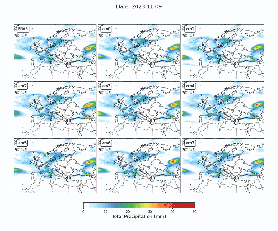
Using the FCN-SFNO model in collaboration with NVIDIA researchers, we generated a 1,008-member ensemble of weather conditions for winter 2023/4. This was made possible through the groundbreaking HENS pipeline, which extensively explores the uncertainty space by using multiple models and varying initial conditions.
JBA’s advanced hydrological models accurately derive river response from input weather conditions while our JFlow hydraulic models solve the shallow water equations to translate river flow into flood depth estimates (Bradbook, 2006). By linking seasonal weather simulations from FCN-SFNO with our hydrology expertise and catastrophe loss modelling, we generated 1,008 counterfactual winter flood scenarios for the Elbe basin, along with their associated population impacts.
The simulated flow rates for five major cities within the Elbe basin are summarised in Figure 4, illustrating the substantial variability in river response. The FCN-SFNO ensemble produces extremes in precipitation which can cause maximum flow rates to increase by at least 50% across all locations. While the 2023/4 winter already experienced elevated river flows, plausible alternative weather patterns throughout the season could have resulted in significantly more severe outcomes, impacting up to three times the population (Figure 5). These results demonstrate the importance of exploring both a broad range of driving precipitation patterns and a broad range of initial antecedent conditions when assessing flood risk.


While understanding the severity of individual flood events is valuable, without also considering the frequency it does not provide a complete picture of the broader risk. The historical season consisted of multiple moderate flood events that collectively led to significant population impacts (Figure 6, orange line). Two sequential events in late December and early January were followed by another in early February, illustrating how sustained basin saturation allowed even low-to-moderate intensity precipitation to generate substantial river peaks.
In contrast to the actual winter, the AI ensemble showcases a diverse range of seasonal flood outcomes that explore the joint distribution between frequency and severity. The scenario that affects the largest population features a single flood event (Figure 6, solid blue line) where a storm in late January caused over 98% of that season’s impact. Meanwhile, the fourth most impactful season in the AI ensemble (over twice as impactful as the actual season in Figure 6) resulted from three smaller but significant flood events, which occur in rapid succession between mid-December and mid-January (Figure 6, dashed blue line).
Overall, these findings emphasise the need to assess flood risk across an entire season rather than focusing solely on isolated extreme events. They also highlight the value of AI-driven simulations in capturing coherent, physically plausible event sequences over medium-long timescales.

A methodological shift for the flood risk industry?
Leveraging NVIDIA’s Earth-2 platform represents an exciting opportunity for JBA Risk Management to use high-quality, AI-generated weather forecasts at the time and spatial scales required for robust flood risk estimation. Use of such forecasts in insurance industry catastrophe models enables the industry to better assess the risk of low-likelihood, high-impact extreme weather events and hence prepare better to provide financial relief for individuals and communities impacted by such events. We are eager to continue exploring how these advancements can shape the future of our industry.