
Twin Typhoons hit Asia’s shores
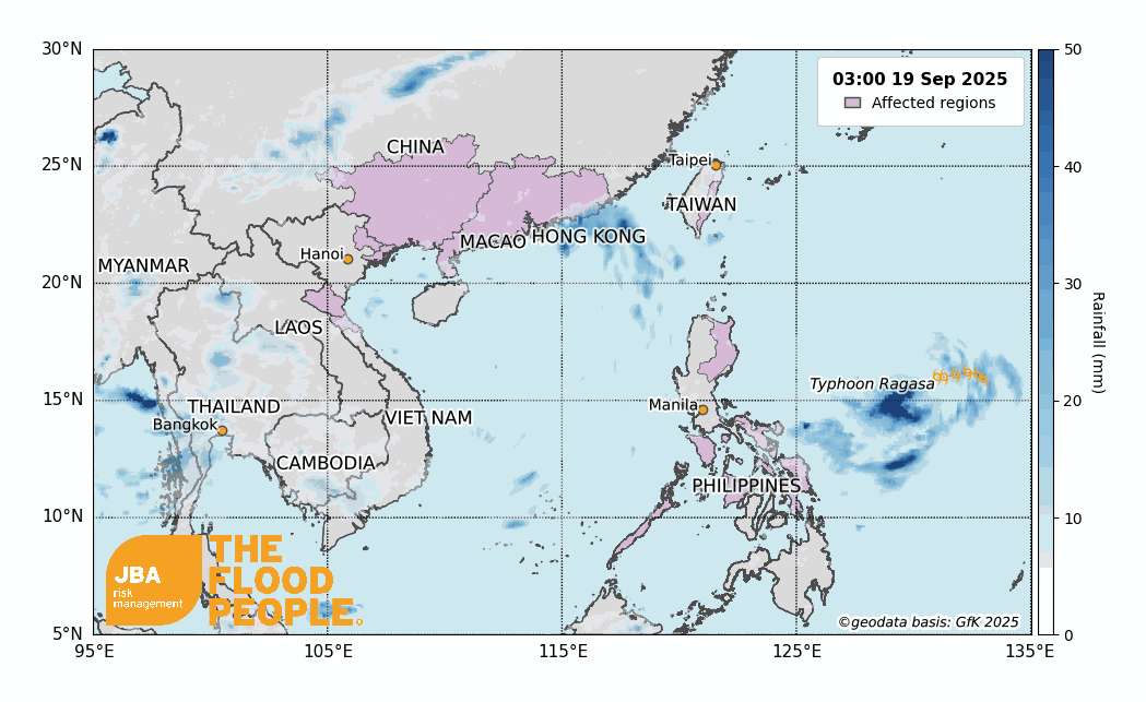
Areas across southern Asia have been hit by two typhoons in late September, causing heavy rainfall, high winds and significant flooding, resulting in the deaths of at least 25 from Typhoon Ragasa (Guardian, 2025a) and more than 30 from Typhoon Bualoi (Guardian, 2025b). Typhoon Ragasa first made landfall on 22 September 2025 in the Philippines with heavy rainfall and winds causing flash flooding as the storm moved over Taiwan and China, before reaching Vietnam and dissipating on 26 September (Aon, 2025). This was closely followed by Typhoon Bualoi, which made landfall on 28 September, affecting both the Philippines and Vietnam once again (BBC, 2025c).
These storms resulted in widespread flooding from the exceedance of 300mm of rainfall in 24 hours in some northern provinces of Vietnam during Typhoon Bualoi (Guardian, 2025a). Prior to this, coastal areas in Vietnam received 100-250mm of rainfall and up to 400mm in some areas from Typhoon Ragasa (Reliefweb, 2025a). The Philippines was another hard-hit area with more than 200mm of rain pouring down on the northern islands from Typhoon Ragasa and the central island during Typhoon Bualoi (Reliefweb, 2025b; Reliefweb, 2025c). In addition to widespread inland flooding, both storms brought destructive storm surge and coastal flooding to densely populated shorelines.
Meteorological overview
Typhoons Ragasa and Bualoi developed within a week of each other in late September 2025 against the backdrop of a strengthening La Niña. By the end of August, sea surface temperatures in the western Pacific were above average, creating favourable conditions for tropical cyclones to develop. In contrast, the eastern Pacific cooled, marking a transition from an El Niño–Southern Oscillation (ENSO)-neutral to La Niña conditions, historically associated with heightened tropical cyclone activity in the western North Pacific (CityUHK, 2025). This shift in oceanic conditions occurred at the tail end of the Southwest Monsoon season (known as “Habagat” in the Philippines), which already brings heavy rains to the northwestern Pacific region, thereby exacerbating flooding risks and impacts (Bathan et al., 2025).
Typhoon Ragasa formed east of the Philippines on 18 September and rapidly intensified as it tracked west-northwest across the Philippine Sea. Ragasa first made landfall in Luzon, Philippines, on 22 September before curving northward toward Taiwan, where further damaging rainfall occurred. On 24 September, Ragasa made a second landfall in Yangjiang, Guangdong Province, with maximum sustained winds of around 140 km/h (Category 2 equivalent) and gusts exceeding 170 km/h (People’s Daily, 2025). The strong sustained winds have crowned Typhoon Ragasa the strongest tropical cyclone in 2025 (Reuters, 2025d). Heavy coastal flooding was reported as storm surge combined with elevated tides, inundating low-lying fishing ports and forcing mass evacuations. The storm brought heavy rain and strong winds to southern China, with forecasts warning of severe rainfall on Guangdong’s coast (CGTN, 2025). Ragasa weakened over land but continued to deliver heavy rainfall into Guangxi and northern Vietnam before dissipating on 26 September.
Typhoon Bualoi (Opong in the Philippines) developed soon after Ragasa in the western Pacific on 22 September, intensifying quickly as it tracked westward across the Philippine Sea. On 25 September, Bualoi made its first landfall in Eastern Samar, before going on to make a total of six landfalls across Eastern Visayas and Mimaropa before re-emerging over the Mindoro Strait on 26 September. After crossing the South China Sea, Bualoi regained strength and intensified into a Category 2-equivalent typhoon before making its seventh and final landfall over Hà Tĩnh Province, Vietnam, on 29 September. Sustained winds of around 130 km/h and heavy rainfall exceeding 300mm in 24 hours triggered widespread flooding and landslides across the northern and north-central regions (Reuters, 2025a). Coastal storm surge inundated low-lying delta areas, overwhelming embankments and forcing tens of thousands of evacuations, while inland river flooding caused further destruction to crops and housing. The storm weakened rapidly over Laos, where it dissipated as a remnant low by 30 September.
Rainfall accumulations were extreme across the region. In Vietnam, totals exceeded 300mm in 24 hours in some provinces during Bualoi’s passage. In particular, Nghe An, Hà Tĩnh and Thanh Hóa provinces in northern central Vietnam bore the brunt of the heavy rainfall, with water levels in rivers and reservoirs rising to critical levels (Reuters, 2025e).

While parts of the Philippines, Taiwan, and Guangdong Province also experienced multi-day accumulations surpassing 500mm. The overlapping storm tracks contributed to widespread flooding across large portions of Southeast and East Asia.

Impacts of Typhoon Ragasa
Typhoon Ragasa had devastating and far-reaching impacts across East and Southeast Asia in September 2025. In the Philippines, at least 11 people were killed, whilst Taiwan experienced even greater losses, with 14 people confirmed dead and 32 injured (Guardian, 2025b). This was largely the result of a barrier lake, created by landslide activity earlier in the year, that burst its banks in Hualien County, unleashing sudden floods that also left 46 people unaccounted for (BBC, 2025a).
As Ragasa tracked towards southern China, it forced the evacuation of more than 2 million people in Guangdong Province (Guardian, 2025a). While Hong Kong avoided a direct landfall, the storm brushed its coastline, leaving 90 people injured amid heavy rain and high winds (BBC, 2025b). Severe flooding was reported in Zhuhai, near Macau, where residents of coastal areas were ordered to evacuate (CNN, 2025). The storm also caused widespread travel disruption, with hundreds of flights cancelled across south China (Reuters, 2025b), and a 36-hour suspension of flights at Hong Kong International Airport before operations resumed (Reuters, 2025c).
Impacts of Typhoon Bualoi
Typhoon Bualoi brought widespread devastation across Southeast Asia in September 2025, leaving at least 30 people dead in the Philippines, Vietnam, and Thailand (Guardian, 2025a). In the Philippines alone, more than 2 million people were affected, with over 350,000 displaced and 407,000 pre-emptively evacuated from vulnerable regions. The storm caused heavy damage to infrastructure, with 243 road sections and 46 bridges disrupted, 143 municipalities experiencing power outages, and more than 5,200 homes reported damaged (GMA, 2025a). The education sector was also hit hard – over 1,300 classrooms sustained varying levels of destruction, impacting an estimated 13.3 million learners and more than half a million teaching staff (GMA 2025b, Inquirer, 2025a). In the Western Visayas, crops were destroyed and damage to bridges and flood control systems meant losses valued at nearly ₱45 million ($750,000 USD) have amounted in the region (Inquirer, 2025b).
In Vietnam, Bualoi’s impacts were equally severe as torrential rains, exceeding 300mm of rainfall in 24 hours in some northern provinces, which triggered widespread flooding and landslides (Guardian, 2025b). The International Federation of Red Cross and Red Crescent Societies reported that rivers in provinces such as Phú Thọ, Thanh Hóa, and Nghe An swelled above critical levels, increasing the risk of flash floods and embankment failures. At least 29 people were killed, 22 were reported missing, and 139 were injured. Tens of thousands of houses were damaged, more than 22,000 hectares of rice and crops were inundated, and widespread power outages left communities in the dark (IFRC, 2025). With thousands of trees uprooted, embankments eroded, and transport networks cut off, recovery across affected areas will likely be prolonged. The Vietnamese government has released a preliminary estimate of 8 trillion dong ($30 million USD) in property damage, accounting for the destruction of transport infrastructure, public facilities, commercial buildings and homes (CNA, 2025). The storm’s destructive passage highlights the mounting threat of typhoons in the region, compounding existing vulnerabilities in rural and urban communities alike.

Coastal hazards: Storm surge and inundation
Both Typhoon Ragasa and Typhoon Bualoi brought severe coastal impacts in addition to widespread inland flooding. Storm surge, wave set-up, and elevated tides combined to inundate low-lying districts across the Philippines, China, and Vietnam. In Eastern Samar and Mimaropa, Bualoi’s repeated landfalls coincided with high tides, flooding ports, damaging fishing fleets, and breaching coastal embankments (AP News, 2025a). Ragasa’s second landfall at Yangjiang drove the surge inland along the Guangdong coast, inundating harbours and forcing mass evacuations (People’s Daily 2025), while Hong Kong experienced waterfront flooding and a 36-hour suspension of operations at its international airport (Reuters, 2025c). Macao’s low-lying Inner Harbour was overtopped (Macao News, 2025), with coastal neighbourhoods inundated despite flood defences (Macao News, 2017). In Vietnam, Bualoi’s final landfall in Hà Tĩnh Province coincided with peak tides, producing a storm surge that overwhelmed delta embankments and displaced tens of thousands, while inland rainfall amplified the flooding (AP News, 2025b). Together, the two storms demonstrated the compounding risks of surge and rainfall in densely populated coastal zones, underscoring the vulnerability of Asia’s port cities and deltas.
JBA’s global coastal flood maps highlight areas most exposed to storm surge flooding. The figures below illustrate flood hazard zones in key coastal provinces affected by Ragasa and Bualoi, underscoring the scale of exposure in densely populated shoreline communities.

Seasonal outlook
The twin typhoons Ragasa and Bualoi struck during a period of transition in ocean-atmosphere conditions across the Pacific. Sea surface temperatures in the eastern equatorial Pacific cooled in late August, prompting a brief La Niña event, but forecasts now suggest a return to ENSO-neutral conditions by the final quarter of 2025 (WMO, 2025). Historically, La Niña phases are associated with heightened tropical cyclone activity in the western North Pacific, but this year’s weak and short-lived signal limits the strength of that relationship.
Seasonal tropical cyclone forecasts indicate that the remainder of the 2025 typhoon season is likely to see near-normal activity levels. Guy Carpenter (2025) notes that a weak La Niña is unlikely to significantly amplify storm frequency, projecting overall basin activity close to climatology. The Tropical Storm Risk (TSR) issued in May similarly anticipates storm numbers slightly below the long-term average (TSR, 2025).
Nevertheless, warm sea surface temperatures across the western Pacific, combined with saturated catchments and damaged infrastructure in recently affected regions, mean that even a near-normal season poses elevated flood risk. This concern is underscored by the development of Tropical Storm Matmo (Paolo), currently being tracked between the paths of Ragasa and Bualoi and forecast to make landfall in the Philippines on 3 October 2025 (JTWC, 2025). With communities still recovering from the twin typhoons, further cyclones could exacerbate flooding and strain the already weakened coastal defences in the Philippines, Vietnam, and southern China. The Ragasa-Bualoi sequence and Paolo’s emergence immediately afterwards highlight the importance of sustained preparedness and adaptation measures in Asia’s densely populated coastal zones.


