
Philippines, Taiwan and China battle massive flooding as Typhoon Gaemi strikes
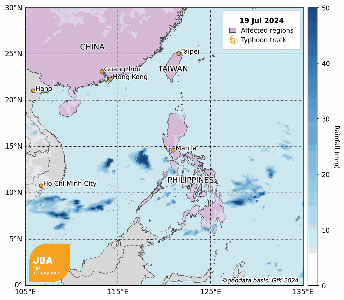
In late July 2024, Typhoon Gaemi brought heavy rains to the Philippines and Taiwan which caused intense flooding and landslides (BBC, 2024a). The effects of the storm were also felt in southern China where floods damaged infrastructure and crops and more than 30 people are reported to have died (China Daily, 2024b). The government of the Philippines declared a “state of calamity” after the country’s capital, Manila, and parts of the main Luzon Island received 300mm of rain, resulting in submerged roads, flight cancellations and school closures. High winds and turbulent waters led to the sinking of an oil tanker and a cargo ship, further exacerbating the impact of the typhoon in the region (CNN, 2024).
Event Overview

Taiwan
Typhoon Gaemi made landfall near Yilan County in Taiwan on 24 July 2024 (BBC, 2024b). Ten people died and hundreds were left injured due to the adverse weather conditions according to the Central Emergency Operation Center (CEOC). With many fallen trees, significant infrastructure damage was reported in Kaohsiung and Tainan, while over 870,000 households suffered power outages (Focus Taiwan, 2024a). Agricultural losses totalled nearly $52 million USD, with significant damage to crops, fisheries and agricultural infrastructure (Focus Taiwan, 2024b).
The storm’s effect forced the country’s airport to close with more than 200 international flights being cancelled. At least 8,000 people were evacuated by the Taiwan authorities and many businesses remained shut on 25 July. Residents emptied supermarket shelves in Taipei and stocked up fearing price rises following the typhoon (BBC, 2024b).
Philippines
Known as Typhoon Carina locally, Gaemi intensified the south-west monsoon (Habagat) in the Philippines (ACAPS, 2024). Heavy monsoonal rains caused severe floods and landslides (Reuters, 2024). As a result, at least 48 people have been killed and over 6 million displaced (AHA Centre, 2024). Hundreds of flights were cancelled, and the financial markets were forced to close in the country (Reuters, 2024).
Around 100mm to 200mm of rainfall was received in various places including Metro Manila, with 2,158 houses destroyed as a result of the storm (ReliefWeb, 2024). The agriculture and fisheries sector took a hit, with the rice industry enduring the brunt of the damage. So far, at least 23,500 farmers and fisherfolk have been affected by these losses (Philippine News Agency, 2024).
China
Hunan Province in southern China experienced extreme rainfall with some areas in Zixing County seeing 645mm in under a day. Damaged homes and a dam break prompted thousands of evacuations in the region (Al Jazeera, 2024). With 118,000 Zixing residents impacted by the mudslides and flooding, rescuers were still searching for dozens of missing people as of 2 August 2024 (CNA, 2024).
Approximately 13,800 hectares of crops were ruined in Hunan. Additionally, in the same region, power was cut in 149 villages, while another 78 settlements suffered a loss of communications. More than 750,000 people in the south-eastern Chinese province of Fujian were also affected by relentless rains that contributed to economic losses exceeding 1.6 billion Yuan (China Daily, 2024a).
Meteorological characteristics
The north-west Pacific is particularly susceptible to frequent tropical cyclones, placing countries along this region at high risk of flooding. Between 1977 and 2016, the north-west Pacific emerged as the most typhoon-prone ocean basin in the world, with an average of 24 typhoons originating in there every year (Pandey and Liou, 2020).
While typhoons in this region travel north-west, their exact path is largely determined by the subtropical high's position during the boreal summer and fall (Hung, Shih and Lin, 2020). When the subtropical high is eastward over the central Pacific, typhoons are guided toward Japan and South Korea. Conversely, a westward subtropical high over Taiwan steers the typhoon towards the South China Sea (Hung, Shih and Lin, 2020). In the case of Typhoon Gaemi, the subtropical high was likely in the middle, sending the typhoon straight through Taiwan and towards south-eastern China.
Typhoon Gaemi originated as a tropical depression east of Palau, consolidating and intensifying and reaching tropical storm magnitude by 20 July. It passed to the north-east of the Philippines as a severe tropical storm, where it exacerbated heavy monsoon rains, strengthening to typhoon magnitude by 22 July.
Typhoon Gaemi underwent rapid intensification from a Category 1 to a Category 4 typhoon on 23 July as it moved north-west, with top wind speeds observed of 230km/h. As Gaemi approached Taiwan it slowed and looped tightly near the coast, weakening in strength to below typhoon intensity but causing heavy rain and widespread flooding. This phenomenon is an occasional feature of typhoons approaching Taiwan, most recently observed in Typhoon Sinaklu in 2008, and results from deflection from Taiwan’s Central Mountain range (Hsu et al., 2018). Gaemi crossed Taiwan, before accelerating and weakening as it moved across the South China sea, making landfall in Fujian Province on 25 July as a tropical storm.
Although Typhoon Gaemi weakened as it reached the coast of Taiwan, it was still the strongest typhoon to hit the island in eight years. Climate change has been linked to an increase in the intensity of typhoons in the north-west Pacific since 1980 (Xiao, 2021). One attribution study has found that due to the ~1°C of global warming we’ve already experienced, the likelihood of a typhoon of the magnitude of Typhoon Gaemi affecting Taiwan in a given year has increased from one in four to one in three (Imperial College, 2024).
Climate change may affect the geographical extent and life cycle of typhoons. Changes in ocean warming patterns could see more typhoons forming northwards of Taiwan and the Philippines, impacting areas such as Japan, South Korea and China. Conversely, other studies anticipate decline in events forming over waters east of the Philippines, like Typhoon Gaemi (Garner et al., 2024). Tropical cyclones may also be more likely to form closer to south-east Asian coastlines, intensify and strengthen more rapidly from a tropical storm, and decay more slowly over land (Garner et al., 2024). If these projections pan out, their culmination would be a northward shift of typhoon tracks and an increase in damage in the north-west Pacific region.
Extreme Value Analysis (EVT)
JBA conducted an Extreme Value Analysis on rainfall data in order to estimate the return period of the event in Taiwan. We fit a Generalised Pareto Distribution (GPD) curve to Deutscher Wetterdienst (DWD, 2024) precipitation data at various locations to produce rainfall exceedance probability curves.
The curves are shown by the solid orange lines in Figure 2, with the 95th percentiles given by the dashed lines and observed values by the blue lines. The analysis is performed with historical rainfall records obtained from Climate Observation Data Inquire Service (CODIS, 2024). Dajin weather station (Station C1V340) is located in Kaohsiung with rainfall data collected from May 1992 to present. The observed data recorded on 24 July 2024 was 887mm and the analysis suggests about 1-in-33-year precipitation.

Historical Events
Typhoon Gaemi’s path of destruction marks a stark resemblance to Typhoon Doksuri from last summer, which also caused severe damage in the Philippines, China, Taiwan and Vietnam (BBC, 2024a). Typhoon Doksuri swept through the Babuyan Islands in northern Philippines, traversed along the east coast of Taiwan, before landing in southern China’s Fujian province and continuing further northwards (CNN, 2023). Beijing, China experienced a 140-year record breaking rainfall when an entire month’s worth of rain fell within 40 hours (Guardian, 2023). Further impacts of Typhoon Doksuri and other similar typhoon events can be found in the table below.

This report is accompanied by a flood footprint for the event - detailing extents and depths of the flooding in areas affected. Download it via logging in to our Client Portal or request a copy by emailing eventresponse@jbarisk.com.


