
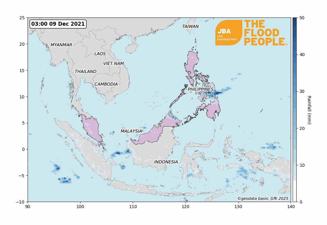
A superstorm swept over the south of the Philippines and intensified severe weather conditions in the Malaysian Peninsula, December 2021
Typhoon Rai initially formed as a tropical storm in the Pacific Ocean and was identified as a named storm on 13 December by the Japan Meteorological Agency (JMA). By 16 December, Rai - otherwise locally known as Odette - intensified into a super typhoon and made landfall across the Philippines at approximately 13:30 local time (ReliefWeb, 2021a).
Typhoon Rai brought strong winds and heavy rainfall that caused at least 389 deaths and displaced around 570,000 people (ReliefWeb, 2021b). The typhoon initially weakened as it crossed the southern Philippines but re-intensified into a Category 5 typhoon as it passed over the South China Sea on 19 December, pushing Hong Kong to issue its first December typhoon signal in the 47 years since Typhoon Irma in 1974 (South China Morning Post, 2021).
Simultaneously, the Malaysian Peninsula was battling with severe floods across multiple states, with flood depths estimated as high as 1.5m and above. This event has been linked to both Rai and Tropical Depression 29W, a storm which rapidly emerged in the east of the peninsula.
With over 36 hours of continuous heavy rain from 17 December, the Malaysian meteorological department reported that accumulated rainfall across the two days was equivalent to the average monthly rainfall in Malaysia; the country’s Environment and Water Ministry have retrospectively identified this as a 1-in-100-year event (The Straits Times, 2021).
The storms in Malaysia have displaced an estimated 70,000 people and are responsible for around 30 fatalities (Aljazeera, 2021).

Causes of flooding on the Malaysian Peninsula
An interesting feature of Typhoon Rai is its simultaneous occurrence with flooding in Malaysia. These floods have been attributed to the interaction between: (1) the seasonal North-east Monsoon; (2) a low-pressure weather system (named Tropical Depression 29W); and (3) Typhoon Rai (Channel News Asia, 2021a).
North-east Monsoon
The South-east Asian region experiences two wet seasons annually (Tan, 2021): the South-west and the North-east monsoons, which occur May-September and November-March respectively (MET Malaysia, 2019). The Malaysian floods of December 2021 are linked to the North-east Monsoon, where cold north-easterly winds carry moisture-laden air across the South China Sea (SCS) towards Malaysia.
Of the two monsoon seasons, the North-east Monsoon typically brings the heaviest rainfall across Malaysia and often triggers severe flooding along the exposed eastern coast of the Malaysian Peninsula, as well as Western Sarawak, when interacting with low pressure systems over the South China Sea (MET Malaysia, 2019).
Under usual conditions, the Titiwangsa mountain range blocks the north-easterly winds, providing shelter to western parts of the peninsula (MET Malaysia, 2019; Suhaila et al., 2010); this time, however, the combined presence of Typhoon Rai and Tropical Depression 29W intensified the effects of the monsoon, allowing the rainfall to extend further west than is usual.
The peninsula was therefore unprepared for the immense amount of rainfall the 2021 monsoon would bring – a 1-in-100-year rainfall event, according to Malaysia’s Environment and Water Ministry (MEWA) - resulting in significant floods along its western coast and central states (The Straits Times, 2021).
Tropical Depression 29W
On 13 December, while Rai was still a Tropical Storm in the Pacific, a low-pressure system was also forming over the SCS. Monsoonal north-easterly winds intensified the cyclonic winds around the low pressure and, on 14 December, JMA upgraded the low-pressure system in the SCS to a Tropical Depression (JMA, 2021a; JMA, 2021b).
On 16 December, the Joint Typhoon Warning Center (JWTC) officially issued a Tropical Cyclone Formation Alert and named the system Tropical Depression 29W (JTWC, 2021a; JTWC, 2021b).
29W first made landfall on the southern tip of Terengganu state along the eastern coast of Malaysia, and eventually weakened and dissipated as it travelled west across the peninsula.

Influence of Super Typhoon Rai
As Typhoon Rai made landfall in the Philippines on 16 December, both Rai and 29W had prominent winds travelling in an anticlockwise direction; as Rai grew stronger, the typhoon strengthened the prevailing north-easterly flow in the SCS region, increasing 29W’s wind strength and picking up more moisture than usual.
It is therefore likely that the presence of Rai directly influenced the severity of flooding on the Malaysian Peninsula.
Impacts and rainfall analysis of Typhoon Rai and 29W
The Philippines
The fifteenth typhoon to hit the Philippines in 2021, Typhoon Rai first hit Siargao Island and continued westwards over the Dinagat Islands, Southern Leyte, Bohol, Cebu, Negros Oriental and Palawan (The New York Times, 2021; ReliefWeb, 2021a).
Rai affected over 4.6 million people in the country, causing at least 389 deaths and displacing around 571,000 people in five regions. Out of the 405,000 houses that have been damaged by the Super Typhoon, 127,800 were destroyed, leaving many homeless over Christmas. Several critical buildings were damage, for instance a municipal doctor from Pilar District Hospital shared that the building’s roof, wards and medical equipment were damaged by the typhoon (ReliefWeb, 2021b; ReliefWeb, 2021c; Rappler, 2022).
The wreckage that Rai left behind has been described as “reminiscent if not worse” than that of Super Typhoon Haiyan in 2013 (The New York Times, 2021).
As of 31 December 2021, the total value of damaged infrastructure and housing is estimated at USD $326 million (PHP $16.72 billion) and USD $550,000 (PHP $28 million) respectively (National Disaster Risk Reduction and Management Council (NDRRMC), 2021).
While most of the damage was due to violent wind speeds, 10 out of 17 regions were flooded as rivers swelled and overflowed, affecting both residential and agricultural land (ReliefWeb, 2021c). The Loboc River, which turned brown from mud and debris, reached the second floor of people’s homes in some locations. The debris-mixed water destroyed homes and resorts in Bohol which was the most affected region (The New York Times, 2021).
The country has also recorded damage to over 86,000ha of agricultural land, amounting to USD $130 million (PHP $6.7 billion) in value of crops lost (NDRRMC, 2021).
Malaysian Peninsula

Tropical Depression 29W made landfall in a southern district of Terengganu state. Of the 11 states and two federal territories on the peninsula, eight have been affected by floods - amongst those, three states (Terengganu, Pahang and Kelantan) faced severe flooding due to their proximity to the tropical depression.
The state of Selangor was also one of the worst affected areas, with almost two thirds of the approximately 30 fatalities in Malaysia occurring here (Aljazeera, 2021). According to Malaysia’s Prime Minister, Selangor received rainfall in excess of the monthly average in a single day (ABC News, 2021) - a record daily total of 380mm was reported on December 18 (Malaymail, 2021a).
The intense flooding has been responsible for the displacement of over 125,000 people nationwide (Reuters, 2022). The effects of flooding have been exacerbated by secondary perils such as the additional 229 landslides that damaged and blocked transport routes, thus preventing aid from reaching further flood-stricken areas (The Straits Times, 2022; New Straits Times, 2021d).
The situation was further aggravated by the ongoing COVID-19 pandemic, as the displaced citizens were faced with the potential spread of the virus (Channel News Asia, 2021b).
Table 1: Reported daily rainfall values (in mm) across affected states on the Malaysian Peninsula between 17 and 18 December 2021 (MEWA, 2021).

The Malaysian government has determined that the extreme rainfall event has a return period of 100 years, although the return period of the flooding is currently unknown (The Straits Times, 2021).
Figure 5 shows the simulated inundation across a town in Selangor state where flooding was observed, according to JBA RML’s 1-in-100-year river (fluvial) and surface water (pluvial) flood maps.

Probabilistic Analysis
It is currently estimated that insured losses alone could reach USD $720 million (Reinsurance News, 2021), with total economic losses as yet unknown.
JBA has carried out a probabilistic analysis of Malaysia’s risk to combined river (fluvial) and surface water (pluvial) flood using a market portfolio that incorporates residential, commercial and industrial assets. The analysis also includes the protective effects of existing flood defences.
Table 2: Estimated economic losses for Malaysia from combined river and surface water flood for a range of return periods generated by JBA’s probabilistic modelling. Source: JBA Risk Management Ltd, 2021.

Significant Historical Event – The Doppelgänger
Typhoon Rai and Tropical Depression 29W are not the first storms to simultaneously result in severe impacts in South-east Asia. In November 2017, Typhoon Damrey coincided with a Tropical Depression in the Gulf of Thailand, impacting the Philippines, Malaysia and Vietnam.
Damrey initially hit the Philippines, causing torrential rain and floods that destroyed over 20ha of rice crops in the town of Aurora alone, amounting to more than PHP $1 million (Philippine Canadian Enquirer, 2017).
The worst impact of Damrey, however, was felt in Vietnam when it made landfall as a Category 2 typhoon on 4 November 2017. UNICEF estimated that four million people across 15 regions in central Vietnam were directly impacted by the typhoon and required aid; a quarter of those were reportedly vulnerable children (Express UK, 2017). Despite evacuation efforts, there were at least 100 casualties, making Damrey the most severe storm that Vietnam has experienced (ReliefWeb, 2017).
At the same time, a Tropical Depression (also named 29W) formed from the remnants of Typhoon Damrey and travelled west across Malaysia and north into the Gulf of Thailand. The storm caused flash floods in Penang and Kedah that killed seven people and displaced over 10,000, and the UNESCO World Heritage site George Town also experienced extensive flooding (Floodlist, 2017; The Weather Channel, 2017).
A weather station in Penang measured 458mm of rainfall in a 24-hour period on 5 November, while Sungai Pinang, a river located north-east of Penang Island, swelled and rose to 3.42m, significantly higher than the danger level of 2.70m. Local authorities reported that flood waters were 3-4m deep in some areas of Penang Island (Floodlist, 2017), swallowing many of the low-lying areas of the island.
Table 3: Comparison of losses seen in the Philippines due to Typhoon Rai and in Vietnam due to Typhoon Damrey. Sources: Dan Tri (2017); Sai Gon Giai Phong Online (2017); Reinsurance News (2017); ReliefWeb (2017).

Flood risk and climate change in south east asia
Annual economic loss due to natural disasters in South-east Asia (SEA) is estimated at USD $86.5 billion; floods are the second largest contributing peril to affect the SEA region and account for 22.5% of the estimated losses (UN, ESCAP, 2020).
Natural disasters within the region are highly trans-boundary in nature, often impacting large swathes of land and multiple countries at once, and aid resources are often strained.
JBA's report last year revealed that insurance penetration rates in many SEA countries are significantly lower than their expected losses, particularly so for Cambodia, Laos, Vietnam and Myanmar, leaving them particularly financially vulnerable to catastrophic flooding.
The general increasing frequency and intensity of weather events and flooding under climate change further emphasises the importance of regional initiatives in managing and mitigating risk.
One such initiative is the South-east Asia Disaster Risk Insurance Facility (SEADRIF) - through SEADRIF, Association of South-east Asian Nations (ASEAN) countries have access to financial planning and protection strategies which reduce the economic and human impacts of natural disasters. JBA is currently supporting the initiative by alerting SEADRIF to major flood events in Lao PDR, enabling rapid financial assistance to be provided.
It’s vital that organisations act now in response to flood risk. We offer flood mapping and probabilistic flood modelling worldwide, including for South-east Asia, which provides flood risk insights at any location globally. This can help re/insurers, financial organisations, and the International Development sector to better understand and manage flood risk.
To find out more about our flood data and how it can help you, get in touch with the team.
This report is covered by JBA’s website terms – please read them here.


