
Widespread flooding in England, Wales and other parts of Europe after mid-November rainfall
Storm Claudia brought record-breaking rainfall and flooding across parts of England, Wales, Spain, Portugal and the Canary Islands, triggering a major incident and numerous flood alerts. In Portugal, the storm sadly caused some fatalities.
Claudia first affected north-west Spain on 12 November, where 80 to 150mm of rain fell within 24 hours, before moving into Portugal the following day, causing more flooding (Guardian, 2025a). By 14 November, the storm had reached the UK, bringing heavy and persistent rain to England and Wales (Natural Resources Wales, 2025a). In South Wales, rainfall totals exceeded 100mm in some locations, and Natural Resources Wales warned of the potential for significant river and surface water flooding (BBC Newsround, 2025). The River Monnow, a tributary of the River Wye, reached record levels, surpassing those observed during previous major flood events, including Storm Dennis in 2020 and Storm Bert in 2024 (Guardian, 2025b). A yellow wind warning was also in force across parts of Wales on 14 November (Natural Resources Wales, 2025a).
Formation and meteorology
Storm Claudia was named by the Spanish Meteorological Service because of its impacts in the Canary Islands, mainland Spain and Portugal (Met Office, 2025a). It developed from an area of low pressure that had previously brought early-season cold and snowy conditions to eastern parts of Canada and the north-eastern United States in early November 2025. As the system moved eastwards across the Atlantic, it deepened after being caught up in an increasingly amplified jet stream bringing severe weather conditions to parts of western Europe (Guardian, 2025a).
During the passage of Storm Claudia across the UK, significant rainfall totals were recorded, which included 119.6mm of rain recorded at Tafalog in Gwent and 80.6mm in Suckley in Worcestershire, between 1800 Thursday and 0600 Saturday. Alongside the rainfall, the storm brought strong winds to northwest Wales and northwest England of 68mph at Warcop Range (Cumbria) and 63mph at Aberdaron (Gwynedd) (Met Office, 2025b). Although there are still drought conditions in some areas of the UK, intense rainfall can cause flash flooding in these areas (University of Reading, 2025).
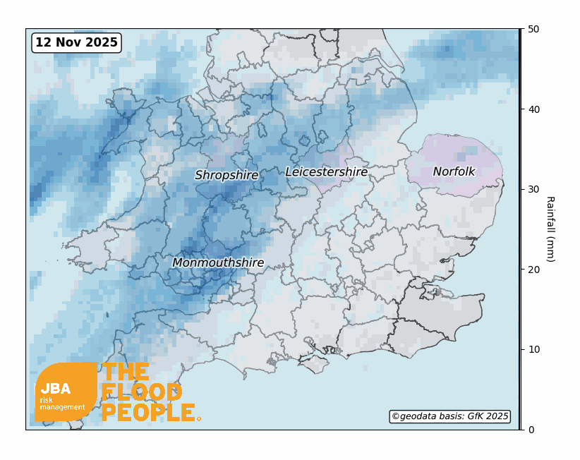
Figure 1 shows the rainfall from 12 to 17 November that fell over England and Wales, highlighting the areas that were subject to the highest levels were Monmouthshire, Shropshire, Leicestershire and Norfolk. Some of the largest impacts were felt in Monmouth, where the River Monnow overtopped its banks after the river had received nearly 5 inches of rain in 5 hours (Wales Online, 2025).
Impacts
Wales and England, Great Britain
The worst impacts were felt in Wales, where in Monmouth a major incident was declared on 15 November (Guardian, 2025b). The River Monnow exceeded bankfull capacity, causing severe flooding that triggered evacuations, water rescues, and left hundreds without power (BBC, 2025a; RTE, 2025). Water levels at Monnow Gate reached a record-breaking 6.658m, surpassing even Storm Dennis in 2020 (BBC, 2025b). Although the River Wye didn’t reach the record level (7.146m) seen during Storm Dennis, a peak of 4.844m was recorded, which contributed to the flooding in the town centre (Figure 2).
A major clean-up began almost immediately, with the community fundraising efforts quickly topping £72,500 (BBC, 2025b). Figure 2 shows the estimated extreme daily river levels at Monnow Gate and the River Wye with JBA’s 20-year fluvial flood map of Monmouth.

Across England, the Environment Agency confirmed at least 57 flooded properties, including homes in Cumbria (Guardian, 2025b). Heavy rain, up to 150mm in parts of England and Wales, fell onto already saturated ground, forcing rivers over their banks and leading to widespread washouts (Channel 4 News, 2025). Roads were shut, rail services were cancelled, and commuters were warned of extremely hazardous travel conditions (4 News, 2025).
Some communities faced direct disruption; schools in Hereford closed, flooding spread across Birmingham, and further evacuations were reported in affected neighbourhoods (Metro, 2025; Yahoo News, 2025).
Ireland
In Ireland, Storm Claudia delivered similar intense conditions. The storm’s heavy rainfall fell on ground already waterlogged from earlier weather systems, amplifying flood risks (Met Éireann, 2025).
Counties including Dublin, Offaly, Laois, Wicklow and Wexford saw rivers overflow, trees brought down, and homes damaged. The River Dodder in Dublin burst its banks, submerging nearby streets and landmarks. Travel was heavily disrupted; flights were cancelled at Dublin Airport, and drivers were urged to exercise extreme caution (The Journal, 2025). Further south, parts of Cork faced road closures from rising water levels, while dramatic flooding was reported in towns like Portarlington and areas of County Wexford (BBC, 2025a; Cork County Council, 2025).
Europe
Storm Claudia left a deep mark across southern Europe, especially in Portugal and Spain. In mainland Portugal, the storm triggered more than 2,400 incidents, primarily flooding events, landslides, and fallen trees, according to the country’s Civil Protection service. (Euro News, 2025a; Euro Weekly, 2025a). The flooding was especially severe in the Lisbon and Tagus Valley regions, where an elderly couple drowned in their home after the waters rose rapidly. (Euro News, 2025b). Meanwhile, in the Algarve town of Albufeira, extreme winds, described by some as tornado-like, ripped through a campsite and hotel, tragically killing an 85-year-old British woman and injuring dozens more (BBC, 2025a, Sky News, 2025).
In Spain, the storm prompted red warnings from AEMET (Agencia Estatal de Meteorología) for heavy rainfall in areas like Ávila and Cáceres, with more than 120 litres per square metre forecast over 12 hours (Euro Weekly, 2025b). Rivers in Castilla y León and Extremadura overflowed after torrential rain — some locations recorded more than 200mm in a single night — and emergency services carried out multiple rescues (The Olive Press, 2025). Experts have also highlighted how Claudia exposed weaknesses in urban drainage and risk-planning; poorly planned urbanisation in flood-prone areas, coupled with more frequent extreme events, could leave more European towns vulnerable in future (Euro News, 2025c).
Historical events
South Wales and south-west England have experienced multiple large flooding events in recent years. Persistent and heavy rainfall during Storm Dennis (15-16 February 2020), which arrived a week after Storm Ciara, resulted in hugely damaging and extensive flooding. The River Wye and River Severn reached their highest ever levels in places, meaning south Wales, Herefordshire, Worcestershire and Shropshire were significantly impacted (Met Office, 2020). In Ireland, although flooding was seen across the middle, south and west of the country, the River Shannon catchment was worst hit (Met Éireann, 2020). For a more detailed analysis of storms in February 2020, please see our Event Response material here.
More recently, Storm Bert brought heavy rain, strong winds and snow to parts of the UK and Ireland in late November 2024. There was localised flooding across the UK, with the worst being felt across south Wales and south-west England (Met Office, 2024). In Ireland, the counties in the west and south saw the heaviest rainfall and most extensive flooding (Met Éireann, 2024).
JBA Flood Maps and services
JBA offers national 5m resolution river, surface water and coastal storm surge flood hazard maps for the UK and the Republic of Ireland.


