
For the first time since the Met Office began annually issuing names for storms, three named storms hit the UK within a seven-day period (BBC News, 2022c), with Storm Eunice labelled the ‘worst storm in decades’ (Guardian, 2022a). Four people lost their lives as a result of the storms and significant damage was caused by high winds and huge waves, as well as by flood.
Both Storms Dudley and Eunice were officially named on 14 February, anticipated to bring strong winds and heavy rain to the UK and Ireland within days of each other.
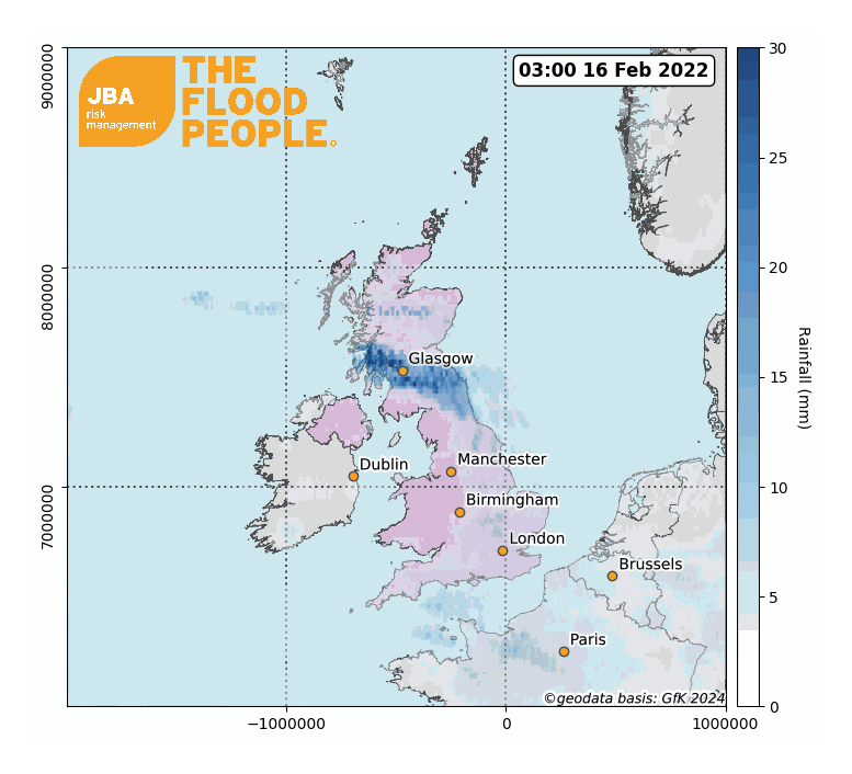
As Storm Dudley approached on 16 February, the Met Office issued amber wind warnings across northern parts of the UK (Met Office 2022a).
Storm Eunice followed close behind, arriving two days later on 18 February. This time, both amber and red wind warnings – signalling threat to life – were issued, resulting in the closure of schools, roads and bridges across the country, as well as UK-wide cancellations of transport services (BBC News, 2022a).
Initial concerns around the coincidence of severe gales with high spring tides led to the Environment Agency and National Resource Wales issuing surge flood warnings along southern and western coastlines, in addition to inland flood warnings across northern England and parts of Scotland.
Only two days after Storm Eunice hit, on 20 February, a third storm named Franklin swept bands of heavy rain across the UK. With rain falling on already-saturated ground, and with river levels higher than usual, close to 200 flood warnings were issued across the UK, including severe warnings for northern England and along the English-Welsh border.
River levels peaked at 4.53m in York on 22 February, causing flooding along low-lying riverside areas (ITV, 2022), with flooding also affecting areas of Shropshire and Worcestershire. Residents were advised to evacuate from riverside properties in Ironbridge, a town also hit by flooding in 2020 and 2021 (BBC News, 2022d).
This confluence of storms has highlighted the risk posed by the combination of wind, surge and heavy rainfall. Since 1980, windstorms in Europe have caused UDS $123 billion of insured losses (AON, 2022) and this February’s UK storms have once again shown the compound impacts of wind and storm surge.
Meteorological Overview
It is not unheard of for the UK to experience back-to-back storms during the winter season. In February 2020, Storms Ciara, Dennis and Jorge brought devastating floods to large swathes of Wales, northern England and the Midlands, and 2015’s Desmond, Eva and Frank remain a benchmark of flooding in the UK.
The recent unsettled weather is the result of an active North Atlantic jet stream. Jet streams are currents of fast-flowing air high up in the atmosphere (around 10km) that circle the Earth, forming along the boundary of sharp temperature gradients. The UK’s weather is commonly influenced by one of these jets – the North Atlantic jet (NAJ) – which forms along the boundary between cold polar air drifting south and warmer air travelling north from the subtropics.
The NAJ flows from west to east, looping in peaks and troughs, and interacting with Atlantic low-pressure systems (‘cyclones’) along the way. Jet troughs act to intensify cyclones near the surface and are therefore associated with regions of increased stormy activity. During the winter months, the NAJ is usually positioned close to the UK, resulting in more frequent and intense storms arriving from the Atlantic.
Conversely, during the summer months, the NAJ migrates northwards and the UK experiences fewer Atlantic storms. The close succession of Storms Dudley, Eunice and Franklin are attributable to a particularly active jet stream (National World, 2022).

Impacts
The early impacts of the storms were caused by high winds, particularly during Storm Eunice. Gusty winds – over 80mph in some areas – uprooted trees and brought down power lines (BBC News, 2022b; Guardian, 2022b), leaving 1.4 million homes without power (Sky News, 2022).
JBA conducted wind gust return period analysis during Storm Eunice for several locations across the UK using Met Office wind hazard maps. Gusts with return periods of at least 25 years were observed at multiple inland locations, with a 200-year return period wind speed recorded at Charlwood near Gatwick Airport. The extreme gust of 122mph reported at The Needles on the Isle of Wight has an estimated return period of over 200 years.
Table 1: Observed wind gusts and return period analysis, based on Met Office wind hazard maps (© British Crown Copyright, the Met Office 2022).

As the storms persisted, the continued heavy rainfall shifted focus onto damage caused by flood waters. The Environment Agency reported on 23 February that 400 properties were flooded across the country, although it is estimated that installation of temporary flood defences protected more than 40,000 properties (Environment Agency, 2022).
The greatest flood impacts across the Yorkshire Dales, South Pennines and Peak District were the result of heavy rainfall on 20 February following landfall of Storm Franklin; for parts of Wales and along the River Severn, the resulting floods were part of a longer event, due to the cumulative effects of heavy rainfall over a three-day period.
Rainfall raised the water levels significantly in many of the UK’s rivers; the River Mersey in Didsbury for example saw a rapid rise of around 3m in a 24-hour period during Storm Franklin (Shoothill GaugeMap, 2022), spilling water out across surrounding areas (Manchester Evening News, 2022).
Flooding continued throughout parts of northern England on 21 February as swollen rivers burst their banks.
Affected areas included Rotherham, Sheffield, Leeds, York and Manchester, as well as smaller towns along the rivers Aire, Nidd, Ouse, Wharf, Mersey, Derwent and Don. River levels in the north of England generally peaked on 20 February, with the exception of York, which peaked two days later.
Media reports and imagery indicate that flood waters in many of these areas were generally restricted to open areas and roads, with limited flooding of buildings; however, multiple properties were flooded in York, with the city council estimating that approximately 140 homes had been affected by floodwater (City of York Council, 2022).
River levels also began to rise across the West Midlands on 18 February, reaching their peak between 21 and 24 February. The resulting overflow led to flooding in parts of Derbyshire as well as many locations along the River Severn, including Shrewsbury, Worcester, Ludlow, Ironbridge, Bridgnorth, and Bewdley. Temporary demountable defences reduced impacts in Ironbridge but suffered breaches in Bewdley and Worcester.
Rainfall analysis

The UK was around 50 percent drier than usual during January, with all regions except western Scotland experiencing lower than average rainfall (Met Office, 2022b).
However, in the lead up to the triple February storms, the jet stream became more active, bringing stormy weather and heavy rain over upland Wales and northern England from the first week of February onwards. The weekend of 12-13 February was also wet, with more than 50mm of rain falling over parts of north Wales, the Lake District and south-west Scotland.
Storm Eunice passed over the UK quickly, which meant rainfall totals were not exceptional, with a maximum recorded value of 29mm at Lake Vyrnwy in Powys.
However, Storm Franklin brought increased rainfall, with a 12-hourly total of 58mm recorded at Shap in Cumbria.
Rainfall totals
Table 2: Reported rainfall values (in mm) across select Environment Agency rain gauges during Storm Franklin.


Return Period Analysis
JBA conducted rainfall return period analysis during Storm Franklin using HadUK-Grid 5km gridded climate data (Met Office, 2022d). There was significant variation across the UK, with return periods ranging between 10 years (Aisgill Moor, Yorkshire Dales) to around 150 years (Redmires Reservoir, Peak District).

Future outlook
According to recent research, climate change has disrupted the North Atlantic Jet (NAJ) through human-influenced warming that has weakened the poleward temperature gradient (Osman et al, 2021). The research suggests that the position of the NAJ could migrate northwards outside the range of its natural variability by 2060; this could lead to a decrease in the frequency and magnitude of extreme weather events across the UK but will more broadly result in changes to temperature and rainfall patterns across mainland Europe.
The series of storms which have caused so much damage across the UK this February highlight the need for increased understanding of the risk caused by compound events, which see flooding exacerbated by storm surge and damage caused by high winds.
The UK had a similar experience in February 2020 when a triple storm – Storms Ciara, Dennis and Jorge – hit parts of England and Wales, bringing immense rainfall and flooding of more than 1,400 properties. The Association of British Insurers (ABI) received over 80,000 claims due to flood and wind damage after Storms Ciara and Dennis; they estimate the post-recovery insurance payouts to their own clients at about £363 million, of which almost 60% (£214 million) were flood related (ABI, 2020).
To help organisations better manage the impacts of windstorm, JBA has partnered with AON to add high resolution storm surge modelling for the UK to its Impact Forecasting Europe windstorm catastrophe model, enabling re/insurers to access comprehensive and timely insights into surge and wind risk.
It is vital that organisations act now to understand both current and future flood risk – JBA offers high resolution hazard maps and probabilistic modelling for all major flood types in the UK, alongside climate change data, to help organisations understand this risk. For more information, get in touch with the team at JBA.
This report is covered by JBA’s website terms – please read them here.


